Avon geodata
Avon (Île-de-France) is a populated place; located in France in Europe/Paris (GMT+2) time zone. With population of 15,009 people, there are 639 cities with bigger population in this country. Compared to other cities in France, 66.4% of cities are located further ↓South; 53.8% of cities are located further ←West and 68.7% of cities have higher elevation than Avon. Note1
Administrative division(s):
- Level 1: Île-de-France
- Level 2: Seine-et-Marne
- Level 3: Arrondissement de Fontainebleau
- Level 4: Avon


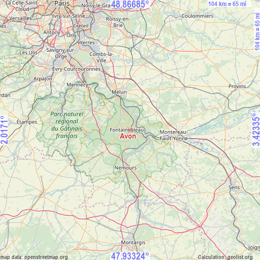
Avon GPS coordinates[2]
48° 24' 7.884" North, 2° 43' 12.792" East
| Map corner | latitude | longitude |
|---|---|---|
| Upper-left | 48.86685°, | 2.0171° |
| Center: | 48.40219°, | 2.72022° |
| Lower-right: | 47.93324°, | 3.42335° |
| Map W x H: | 103.8×103.8 km | = 64.5×64.5mi |
| max Lat: | 51.07786° ⇑33.6% North |
| Avon: | 48.40219° |
| min Lat: | ⇓66.4% South 41.3874° |
| min Long | Avon | max Long |
| -5.08615° | 2.72022° | 9.52242° |
| W 53.8%⇐ | ⇒46.2% E |
Elevation
Elevation of Avon is 81 m = 266 ft, and this is 112.7 m = 370 ft below average elevation for this country.
| Max E: |
2333 m = 7654 ft | 68.7% |
| Avg. | 193.7 m = 635 ft | |
| Avon | 81 m = 266 ft | |
Min E: |
-1 m = -3 ft | 31.3% |
See also: France elevation on elevation.city.
Geographical zone
Avon is located in North temperate zone (between Tropic of Cancer and the Arctic Circle). Distance of this North polar circle is 2019.4 km =1254.8 mi to North.| Distance of | km | miles | from Avon |
|---|---|---|---|
| North Pole | 4625.2 | 2874 | to North |
| Arctic Circle | 2019.4 | 1254.8 | to North |
| Tropic Cancer | 2775.9 | 1724.9 | to South |
| Equator | 5381.8 | 3344.1 | to South |


Nearby cities:
15 places around Avon: (largest is in red/bold)
• Bois-le-Roi
8 km =5 mi,  351°
351°
• Bourron-Marlotte
7 km =4.3 mi,  192°
192°
• Champagne-sur-Seine
5.8 km =3.6 mi,  94°
94°
• Fontainebleau
1.6 km =1 mi,  299°
299°
• Féricy
8.8 km =5.5 mi,  42°
42°
• Héricy
6.1 km =3.8 mi,  32°
32°
• Montigny-sur-Loing
7.6 km =4.7 mi,  166°
166°
• Moret-sur-Loing
7.9 km =4.9 mi,  114°
114°
• Recloses
8.4 km =5.2 mi,  222°
222°
• Saint-Mammès
7.3 km =4.5 mi, 105°
• Samois-sur-Seine
6 km =3.7 mi,  21°
21°
• Samoreau
4 km =2.5 mi, 40°
• Thomery
5.1 km =3.2 mi,  83°
83°
• Veneux-les-Sablons
6.1 km =3.8 mi,  115°
115°
• Vulaines-sur-Seine
4.7 km =2.9 mi, 44°
Sources, notices
• [Note1] Compared only with cities in France existing in our database
• [Src1] Map data: © OpenStreetMap contributors (CC-BY-SA)
• [Src2] Other city data from geonames.org with taken over terms of usage.
• [Src3] Geographical zone / Annual Mean Temperature by Robert A. Rohde @ Wikipedia
