Folembray geodata
Folembray (Hauts-de-France) is a populated place; located in France in Europe/Paris (GMT+2) time zone. With population of 1,500 people, there are 6188 cities with bigger population in this country. Compared to other cities in France, 89.9% of cities are located further ↓South; 61.9% of cities are located further ←West and 67.4% of cities have higher elevation than Folembray. Note1
Administrative division(s):
- Level 1: Hauts-de-France
- Level 2: Département de l'Aisne
- Level 3: Arrondissement de Laon
- Level 4: Folembray


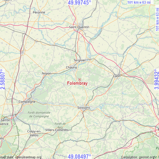
Folembray GPS coordinates[2]
49° 32' 36.024" North, 3° 17' 28.284" East
| Map corner | latitude | longitude |
|---|---|---|
| Upper-left | 49.99745°, | 2.58807° |
| Center: | 49.54334°, | 3.29119° |
| Lower-right: | 49.08497°, | 3.99432° |
| Map W x H: | 101.5×101.5 km | = 63.1×63.1mi |
| max Lat: | 51.07786° ⇑10.1% North |
| Folembray: | 49.54334° |
| min Lat: | ⇓89.9% South 41.3874° |
| min Long | Folembray | max Long |
| -5.08615° | 3.29119° | 9.52242° |
| W 61.9%⇐ | ⇒38.1% E |
Elevation
Elevation of Folembray is 84 m = 276 ft, and this is 109.7 m = 360 ft below average elevation for this country.
| Max E: |
2333 m = 7654 ft | 67.4% |
| Avg. | 193.7 m = 635 ft | |
| Folembray | 84 m = 276 ft | |
Min E: |
-1 m = -3 ft | 32.6% |
See also: France elevation on elevation.city.
Geographical zone
Folembray is located in North temperate zone (between Tropic of Cancer and the Arctic Circle). Distance of this North polar circle is 1892.5 km =1175.9 mi to North.| Distance of | km | miles | from Folembray |
|---|---|---|---|
| North Pole | 4498.4 | 2795.2 | to North |
| Arctic Circle | 1892.5 | 1175.9 | to North |
| Tropic Cancer | 2902.8 | 1803.7 | to South |
| Equator | 5508.7 | 3422.9 | to South |


Nearby cities:
15 places around Folembray: (largest is in red/bold)
• Amigny-Rouy
7.5 km =4.7 mi,  7°
7°
• Autreville
5.9 km =3.7 mi,  321°
321°
• Barisis
5.4 km =3.4 mi,  34°
34°
• Bertaucourt-Epourdon
10.5 km =6.5 mi,  39°
39°
• Bichancourt
6.6 km =4.1 mi,  307°
307°
• Brancourt-en-Laonnois
9.8 km =6.1 mi,  109°
109°
• Chauny
9.5 km =5.9 mi,  326°
326°
• Condren
9.6 km =6 mi,  355°
355°
• Coucy-le-Château-Auffrique
3.4 km =2.1 mi,  136°
136°
• Ognes
10.4 km =6.5 mi, 317°
• Prémontré
8.8 km =5.5 mi,  92°
92°
• Saint-Gobain
8.5 km =5.3 mi,  46°
46°
• Sinceny
6.7 km =4.2 mi, 331°
• Trosly-Loire
5.3 km =3.3 mi,  239°
239°
• Viry-Noureuil
10.5 km =6.5 mi,  340°
340°
Sources, notices
• [Note1] Compared only with cities in France existing in our database
• [Src1] Map data: © OpenStreetMap contributors (CC-BY-SA)
• [Src2] Other city data from geonames.org with taken over terms of usage.
• [Src3] Geographical zone / Annual Mean Temperature by Robert A. Rohde @ Wikipedia
