Trosly-Loire geodata
Trosly-Loire (Hauts-de-France) is a populated place; located in France in Europe/Paris (GMT+2) time zone. With population of 621 people, there are 12967 cities with bigger population in this country. Compared to other cities in France, 89.6% of cities are located further ↓South; 61% of cities are located further ←West and 72.6% of cities have higher elevation than Trosly-Loire. Note1
Administrative division(s):
- Level 1: Hauts-de-France
- Level 2: Département de l'Aisne
- Level 3: Arrondissement de Laon
- Level 4: Trosly-Loire


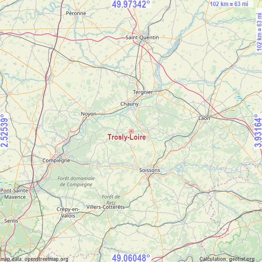
Trosly-Loire GPS coordinates[2]
49° 31' 8.688" North, 3° 13' 42.636" East
| Map corner | latitude | longitude |
|---|---|---|
| Upper-left | 49.97342°, | 2.52539° |
| Center: | 49.51908°, | 3.22851° |
| Lower-right: | 49.06048°, | 3.93164° |
| Map W x H: | 101.5×101.5 km | = 63.1×63.1mi |
| max Lat: | 51.07786° ⇑10.4% North |
| Trosly-Loire: | 49.51908° |
| min Lat: | ⇓89.6% South 41.3874° |
| min Long | Trosly-Loire | max Long |
| -5.08615° | 3.22851° | 9.52242° |
| W 61%⇐ | ⇒39% E |
Elevation
Elevation of Trosly-Loire is 72 m = 236 ft, and this is 121.7 m = 399 ft below average elevation for this country.
| Max E: |
2333 m = 7654 ft | 72.6% |
| Avg. | 193.7 m = 635 ft | |
| Trosly-Loire | 72 m = 236 ft | |
Min E: |
-1 m = -3 ft | 27.4% |
See also: France elevation on elevation.city.
Geographical zone
Trosly-Loire is located in North temperate zone (between Tropic of Cancer and the Arctic Circle). Distance of this North polar circle is 1895.2 km =1177.6 mi to North.| Distance of | km | miles | from Trosly-Loire |
|---|---|---|---|
| North Pole | 4501.1 | 2796.9 | to North |
| Arctic Circle | 1895.2 | 1177.6 | to North |
| Tropic Cancer | 2900.1 | 1802 | to South |
| Equator | 5506 | 3421.3 | to South |


Nearby cities:
15 places around Trosly-Loire: (largest is in red/bold)
• Amigny-Rouy
11.5 km =7.1 mi,  28°
28°
• Appilly
10.8 km =6.7 mi,  311°
311°
• Autreville
7.4 km =4.6 mi,  6°
6°
• Autrêches
11.2 km =7 mi,  222°
222°
• Barisis
10.4 km =6.5 mi,  46°
46°
• Bichancourt
6.8 km =4.2 mi,  353°
353°
• Blérancourt
5.7 km =3.5 mi,  267°
267°
• Chauny
10.7 km =6.6 mi,  356°
356°
• Coucy-le-Château-Auffrique
6.9 km =4.3 mi,  88°
88°
• Cuts
9.5 km =5.9 mi,  278°
278°
• Folembray
5.3 km =3.3 mi,  59°
59°
• Fontenoy
12.6 km =7.8 mi,  189°
189°
• Ognes
10.7 km =6.6 mi, 346°
• Sinceny
8.7 km =5.4 mi, 8°
• Viry-Noureuil
12.6 km =7.8 mi,  4°
4°
Sources, notices
• [Note1] Compared only with cities in France existing in our database
• [Src1] Map data: © OpenStreetMap contributors (CC-BY-SA)
• [Src2] Other city data from geonames.org with taken over terms of usage.
• [Src3] Geographical zone / Annual Mean Temperature by Robert A. Rohde @ Wikipedia
