Fleurey-sur-Ouche geodata
Fleurey-sur-Ouche (Bourgogne-Franche-Comté) is a populated place; located in France in Europe/Paris (GMT+2) time zone. With population of 1,297 people, there are 7046 cities with bigger population in this country. Compared to other cities in France, 51.4% of cities are located further ↑North; 75.9% of cities are located further ←West and 79.7% of cities have lower elevation than Fleurey-sur-Ouche. Note1
Administrative division(s):
- Level 1: Bourgogne-Franche-Comté
- Level 2: Département de la Côte-d'Or
- Level 3: Arrondissement de Dijon
- Level 4: Fleurey-sur-Ouche


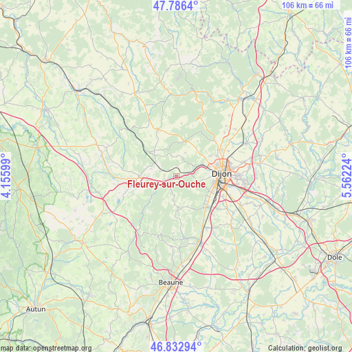
Fleurey-sur-Ouche GPS coordinates[2]
47° 18' 42.552" North, 4° 51' 32.796" East
| Map corner | latitude | longitude |
|---|---|---|
| Upper-left | 47.7864°, | 4.15599° |
| Center: | 47.31182°, | 4.85911° |
| Lower-right: | 46.83294°, | 5.56224° |
| Map W x H: | 106×106 km | = 65.9×65.9mi |
| max Lat: | 51.07786° ⇑51.4% North |
| Fleurey-sur-Ouche: | 47.31182° |
| min Lat: | ⇓48.6% South 41.3874° |
| min Long | Fleurey-sur-Ouc | max Long |
| -5.08615° | 4.85911° | 9.52242° |
| W 75.9%⇐ | ⇒24.1% E |
Elevation
Elevation of Fleurey-sur-Ouche is 287 m = 942 ft, and this is 93.3 m = 306 ft above average elevation for this country.
| Max E: |
2333 m = 7654 ft | 20.3% |
| Fleurey-sur-Ouche | 287 m 942 ft | |
| Avg. | 193.7 m = 635 ft | |
Min E: |
-1 m = -3 ft | 79.7% |
See also: France elevation on elevation.city.
Geographical zone
Fleurey-sur-Ouche is located in North temperate zone (between Tropic of Cancer and the Arctic Circle). Distance of this North polar circle is 2140.6 km =1330.1 mi to North.| Distance of | km | miles | from Fleurey-sur-Ouche |
|---|---|---|---|
| North Pole | 4746.5 | 2949.3 | to North |
| Arctic Circle | 2140.6 | 1330.1 | to North |
| Tropic Cancer | 2654.7 | 1649.6 | to South |
| Equator | 5260.6 | 3268.8 | to South |


Nearby cities:
15 places around Fleurey-sur-Ouche: (largest is in red/bold)
• Blaisy-Bas
11.2 km =7 mi,  305°
305°
• Brochon
11.6 km =7.2 mi,  134°
134°
• Chenôve
11.2 km =7 mi,  100°
100°
• Corcelles-les-Monts
6.4 km =4 mi,  106°
106°
• Couchey
11 km =6.8 mi,  121°
121°
• Daix
11.5 km =7.1 mi,  67°
67°
• Fixin
11.4 km =7.1 mi, 130°
• Hauteville-lès-Dijon
11.8 km =7.3 mi,  59°
59°
• Marsannay-la-Côte
10.8 km =6.7 mi, 114°
• Mâlain
4.8 km =3 mi,  289°
289°
• Plombières-lès-Dijon
8.5 km =5.3 mi, 73°
• Sainte-Marie-sur-Ouche
5.5 km =3.4 mi,  239°
239°
• Sombernon
11.3 km =7 mi,  268°
268°
• Talant
11.6 km =7.2 mi,  76°
76°
• Velars-sur-Ouche
3.6 km =2.2 mi, 76°
Sources, notices
• [Note1] Compared only with cities in France existing in our database
• [Src1] Map data: © OpenStreetMap contributors (CC-BY-SA)
• [Src2] Other city data from geonames.org with taken over terms of usage.
• [Src3] Geographical zone / Annual Mean Temperature by Robert A. Rohde @ Wikipedia
