Blaisy-Bas geodata
Blaisy-Bas (Bourgogne-Franche-Comté) is a populated place; located in France in Europe/Paris (GMT+2) time zone. With population of 607 people, there are 13209 cities with bigger population in this country. Compared to other cities in France, 50.4% of cities are located further ↑North; 74.2% of cities are located further ←West and 89.2% of cities have lower elevation than Blaisy-Bas. Note1
Administrative division(s):
- Level 1: Bourgogne-Franche-Comté
- Level 2: Département de la Côte-d'Or
- Level 3: Arrondissement de Dijon
- Level 4: Blaisy-Bas


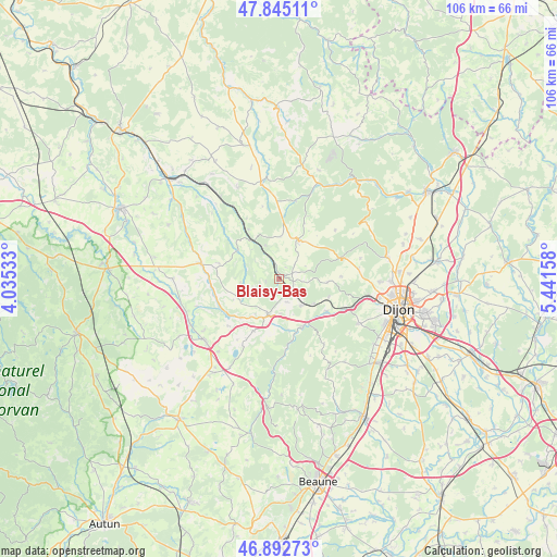
Blaisy-Bas GPS coordinates[2]
47° 22' 15.852" North, 4° 44' 18.42" East
| Map corner | latitude | longitude |
|---|---|---|
| Upper-left | 47.84511°, | 4.03533° |
| Center: | 47.37107°, | 4.73845° |
| Lower-right: | 46.89273°, | 5.44158° |
| Map W x H: | 105.9×105.9 km | = 65.8×65.8mi |
| max Lat: | 51.07786° ⇑50.4% North |
| Blaisy-Bas: | 47.37107° |
| min Lat: | ⇓49.6% South 41.3874° |
| min Long | Blaisy-Bas | max Long |
| -5.08615° | 4.73845° | 9.52242° |
| W 74.2%⇐ | ⇒25.8% E |
Elevation
Elevation of Blaisy-Bas is 410 m = 1345 ft, and this is 216.3 m = 710 ft above average elevation for this country.
| Max E: |
2333 m = 7654 ft | 10.8% |
| Blaisy-Bas | 410 m 1345 ft | |
| Avg. | 193.7 m = 635 ft | |
Min E: |
-1 m = -3 ft | 89.2% |
See also: France elevation on elevation.city.
Geographical zone
Blaisy-Bas is located in North temperate zone (between Tropic of Cancer and the Arctic Circle). Distance of this North polar circle is 2134 km =1326 mi to North.| Distance of | km | miles | from Blaisy-Bas |
|---|---|---|---|
| North Pole | 4739.9 | 2945.2 | to North |
| Arctic Circle | 2134 | 1326 | to North |
| Tropic Cancer | 2661.3 | 1653.7 | to South |
| Equator | 5267.2 | 3272.9 | to South |


Nearby cities:
15 places around Blaisy-Bas: (largest is in red/bold)
• Ahuy
21.3 km =13.2 mi,  90°
90°
• Corcelles-les-Monts
17.4 km =10.8 mi,  119°
119°
• Daix
19.9 km =12.4 mi,  96°
96°
• Fleurey-sur-Ouche
11.2 km =7 mi,  125°
125°
• Fontaine-lès-Dijon
21.5 km =13.4 mi, 98°
• Hauteville-lès-Dijon
19.2 km =11.9 mi, 91°
• Messigny-et-Vantoux
21.3 km =13.2 mi,  79°
79°
• Mâlain
6.7 km =4.2 mi,  137°
137°
• Plombières-lès-Dijon
17.7 km =11 mi, 103°
• Pouilly-en-Auxois
18.3 km =11.4 mi,  228°
228°
• Sainte-Marie-sur-Ouche
10.3 km =6.4 mi,  154°
154°
• Sombernon
7.1 km =4.4 mi,  197°
197°
• Talant
20.7 km =12.9 mi, 100°
• Velars-sur-Ouche
13.9 km =8.6 mi,  114°
114°
• Vitteaux
15.1 km =9.4 mi,  281°
281°
Sources, notices
• [Note1] Compared only with cities in France existing in our database
• [Src1] Map data: © OpenStreetMap contributors (CC-BY-SA)
• [Src2] Other city data from geonames.org with taken over terms of usage.
• [Src3] Geographical zone / Annual Mean Temperature by Robert A. Rohde @ Wikipedia
