Ferrette geodata
Ferrette (Grand Est) is a populated place; located in France in Europe/Paris (GMT+2) time zone. With population of 1,047 people, there are 8486 cities with bigger population in this country. Compared to other cities in France, 51.1% of cities are located further ↓South; 96.6% of cities are located further ←West and 93.3% of cities have lower elevation than Ferrette. Note1
Administrative division(s):
- Level 1: Grand Est
- Level 2: Haut-Rhin
- Level 3: Altkirch
- Level 4: Ferrette


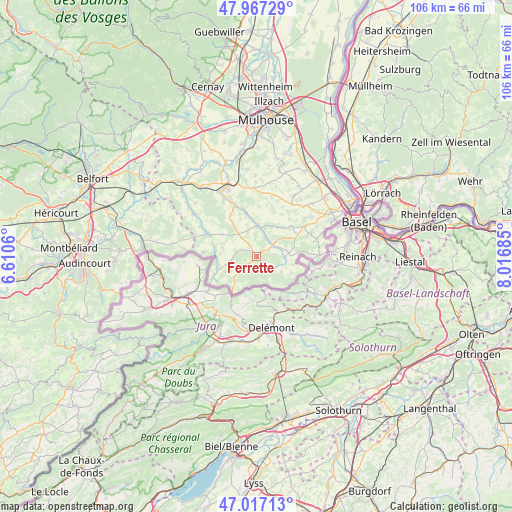
Ferrette GPS coordinates[2]
47° 29' 39.696" North, 7° 18' 49.392" East
| Map corner | latitude | longitude |
|---|---|---|
| Upper-left | 47.96729°, | 6.6106° |
| Center: | 47.49436°, | 7.31372° |
| Lower-right: | 47.01713°, | 8.01685° |
| Map W x H: | 105.6×105.6 km | = 65.6×65.6mi |
| max Lat: | 51.07786° ⇑48.9% North |
| Ferrette: | 47.49436° |
| min Lat: | ⇓51.1% South 41.3874° |
| min Long | Ferrette | max Long |
| -5.08615° | 7.31372° | 9.52242° |
| W 96.6%⇐ | ⇒3.4% E |
Elevation
Elevation of Ferrette is 515 m = 1690 ft, and this is 321.3 m = 1054 ft above average elevation for this country.
| Max E: |
2333 m = 7654 ft | 6.7% |
| Ferrette | 515 m 1690 ft | |
| Avg. | 193.7 m = 635 ft | |
Min E: |
-1 m = -3 ft | 93.3% |
See also: France elevation on elevation.city.
Geographical zone
Ferrette is located in North temperate zone (between Tropic of Cancer and the Arctic Circle). Distance of this North polar circle is 2120.3 km =1317.5 mi to North.| Distance of | km | miles | from Ferrette |
|---|---|---|---|
| North Pole | 4726.2 | 2936.7 | to North |
| Arctic Circle | 2120.3 | 1317.5 | to North |
| Tropic Cancer | 2675 | 1662.2 | to South |
| Equator | 5280.9 | 3281.4 | to South |


Nearby cities:
15 places around Ferrette: (largest is in red/bold)
• Bisel
8.5 km =5.3 mi,  302°
302°
• Durlinsdorf
5.6 km =3.5 mi,  260°
260°
• Durmenach
4.3 km =2.7 mi,  26°
26°
• Grentzingen
7.8 km =4.8 mi,  352°
352°
• Muespach-le-Haut
8.9 km =5.5 mi,  48°
48°
• Mœrnach
4.8 km =3 mi,  277°
277°
• Oberdorf
7.3 km =4.5 mi,  355°
355°
• Oltingue
5.9 km =3.7 mi,  93°
93°
• Raedersdorf
4.5 km =2.8 mi,  119°
119°
• Riespach
5.4 km =3.4 mi,  338°
338°
• Roppentzwiller
5.3 km =3.3 mi,  14°
14°
• Steinsoultz
6.6 km =4.1 mi,  15°
15°
• Vieux-Ferrette
1.3 km =0.8 mi,  316°
316°
• Waldighofen
6.2 km =3.9 mi,  0°
0°
• Werentzhouse
4.1 km =2.5 mi, 49°
Sources, notices
• [Note1] Compared only with cities in France existing in our database
• [Src1] Map data: © OpenStreetMap contributors (CC-BY-SA)
• [Src2] Other city data from geonames.org with taken over terms of usage.
• [Src3] Geographical zone / Annual Mean Temperature by Robert A. Rohde @ Wikipedia
