Roppentzwiller geodata
Roppentzwiller (Grand Est) is a populated place; located in France in Europe/Paris (GMT+2) time zone. With population of 695 people, there are 11873 cities with bigger population in this country. Compared to other cities in France, 51.8% of cities are located further ↓South; 96.8% of cities are located further ←West and 87% of cities have lower elevation than Roppentzwiller. Note1
Administrative division(s):
- Level 1: Grand Est
- Level 2: Haut-Rhin
- Level 3: Altkirch
- Level 4: Roppentzwiller


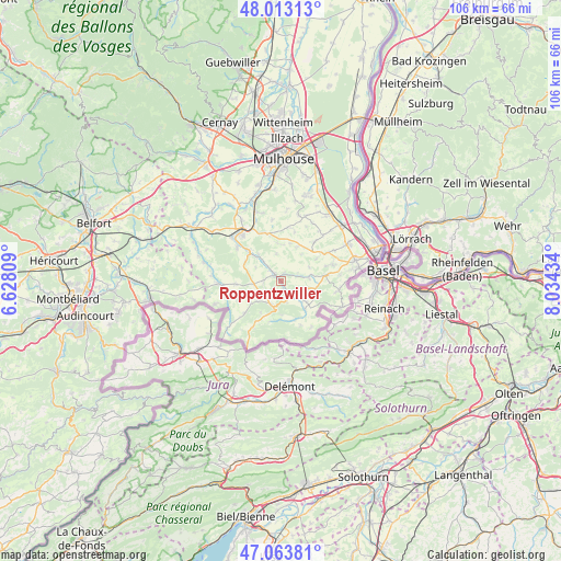
Roppentzwiller GPS coordinates[2]
47° 32' 26.232" North, 7° 19' 52.356" East
| Map corner | latitude | longitude |
|---|---|---|
| Upper-left | 48.01313°, | 6.62809° |
| Center: | 47.54062°, | 7.33121° |
| Lower-right: | 47.06381°, | 8.03434° |
| Map W x H: | 105.6×105.6 km | = 65.6×65.6mi |
| max Lat: | 51.07786° ⇑48.2% North |
| Roppentzwiller: | 47.54062° |
| min Lat: | ⇓51.8% South 41.3874° |
| min Long | Roppentzwiller | max Long |
| -5.08615° | 7.33121° | 9.52242° |
| W 96.8%⇐ | ⇒3.2% E |
Elevation
Elevation of Roppentzwiller is 374 m = 1227 ft, and this is 180.3 m = 592 ft above average elevation for this country.
| Max E: |
2333 m = 7654 ft | 13% |
| Roppentzwiller | 374 m 1227 ft | |
| Avg. | 193.7 m = 635 ft | |
Min E: |
-1 m = -3 ft | 87% |
See also: France elevation on elevation.city.
Geographical zone
Roppentzwiller is located in North temperate zone (between Tropic of Cancer and the Arctic Circle). Distance of this North polar circle is 2115.2 km =1314.3 mi to North.| Distance of | km | miles | from Roppentzwiller |
|---|---|---|---|
| North Pole | 4721 | 2933.5 | to North |
| Arctic Circle | 2115.2 | 1314.3 | to North |
| Tropic Cancer | 2680.1 | 1665.3 | to South |
| Equator | 5286 | 3284.6 | to South |


Nearby cities:
15 places around Roppentzwiller: (largest is in red/bold)
• Durmenach
1.5 km =0.9 mi,  156°
156°
• Ferrette
5.3 km =3.3 mi,  194°
194°
• Grentzingen
3.5 km =2.2 mi,  317°
317°
• Heimersdorf
7.6 km =4.7 mi,  297°
297°
• Jettingen
7.2 km =4.5 mi,  25°
25°
• Muespach-le-Haut
5.4 km =3.4 mi,  82°
82°
• Mœrnach
7.6 km =4.7 mi,  233°
233°
• Oberdorf
2.8 km =1.7 mi, 318°
• Oltingue
7.1 km =4.4 mi,  140°
140°
• Raedersdorf
7.8 km =4.8 mi, 160°
• Riespach
3.3 km =2.1 mi,  267°
267°
• Steinsoultz
1.3 km =0.8 mi,  19°
19°
• Vieux-Ferrette
4.7 km =2.9 mi,  208°
208°
• Waldighofen
1.6 km =1 mi,  312°
312°
• Werentzhouse
3.1 km =1.9 mi, 144°
Sources, notices
• [Note1] Compared only with cities in France existing in our database
• [Src1] Map data: © OpenStreetMap contributors (CC-BY-SA)
• [Src2] Other city data from geonames.org with taken over terms of usage.
• [Src3] Geographical zone / Annual Mean Temperature by Robert A. Rohde @ Wikipedia
