Oberdorf geodata
Oberdorf (Grand Est) is a populated place; located in France in Europe/Paris (GMT+2) time zone. With population of 595 people, there are 13406 cities with bigger population in this country. Compared to other cities in France, 52.1% of cities are located further ↓South; 96.6% of cities are located further ←West and 84.8% of cities have lower elevation than Oberdorf. Note1


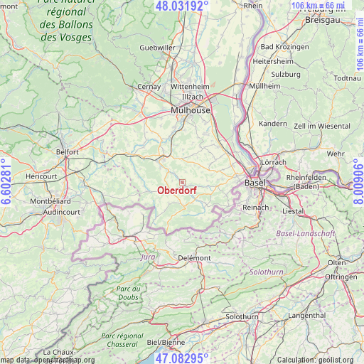
Oberdorf GPS coordinates[2]
47° 33' 34.488" North, 7° 18' 21.384" East
| Map corner | latitude | longitude |
|---|---|---|
| Upper-left | 48.03192°, | 6.60281° |
| Center: | 47.55958°, | 7.30594° |
| Lower-right: | 47.08295°, | 8.00906° |
| Map W x H: | 105.5×105.5 km | = 65.6×65.6mi |
| max Lat: | 51.07786° ⇑47.9% North |
| Oberdorf: | 47.55958° |
| min Lat: | ⇓52.1% South 41.3874° |
| min Long | Oberdorf | max Long |
| -5.08615° | 7.30594° | 9.52242° |
| W 96.6%⇐ | ⇒3.4% E |
Elevation
Elevation of Oberdorf is 343 m = 1125 ft, and this is 149.3 m = 490 ft above average elevation for this country.
| Max E: |
2333 m = 7654 ft | 15.2% |
| Oberdorf | 343 m 1125 ft | |
| Avg. | 193.7 m = 635 ft | |
Min E: |
-1 m = -3 ft | 84.8% |
See also: France elevation on elevation.city.
Geographical zone
Oberdorf is located in North temperate zone (between Tropic of Cancer and the Arctic Circle). Distance of this North polar circle is 2113 km =1313 mi to North.| Distance of | km | miles | from Oberdorf |
|---|---|---|---|
| North Pole | 4718.9 | 2932.2 | to North |
| Arctic Circle | 2113 | 1313 | to North |
| Tropic Cancer | 2682.2 | 1666.6 | to South |
| Equator | 5288.1 | 3285.9 | to South |


Nearby cities:
15 places around Oberdorf: (largest is in red/bold)
• Bisel
7.1 km =4.4 mi,  247°
247°
• Durmenach
4.2 km =2.6 mi,  144°
144°
• Ferrette
7.3 km =4.5 mi,  175°
175°
• Grentzingen
0.7 km =0.4 mi,  317°
317°
• Heimersdorf
5 km =3.1 mi,  286°
286°
• Hirsingue
5.1 km =3.2 mi,  308°
308°
• Jettingen
6.6 km =4.1 mi,  49°
49°
• Muespach-le-Haut
7.4 km =4.6 mi,  100°
100°
• Riespach
2.6 km =1.6 mi,  212°
212°
• Roppentzwiller
2.8 km =1.7 mi, 138°
• Steinsoultz
2.5 km =1.6 mi,  110°
110°
• Vieux-Ferrette
6.3 km =3.9 mi, 183°
• Waldighofen
1.2 km =0.7 mi,  145°
145°
• Werentzhouse
5.9 km =3.7 mi, 141°
• Wittersdorf
7.3 km =4.5 mi,  341°
341°
Sources, notices
• [Note1] Compared only with cities in France existing in our database
• [Src1] Map data: © OpenStreetMap contributors (CC-BY-SA)
• [Src2] Other city data from geonames.org with taken over terms of usage.
• [Src3] Geographical zone / Annual Mean Temperature by Robert A. Rohde @ Wikipedia
