Riespach geodata
Riespach (Grand Est) is a populated place; located in France in Europe/Paris (GMT+2) time zone. With population of 702 people, there are 11777 cities with bigger population in this country. Compared to other cities in France, 51.8% of cities are located further ↓South; 96.4% of cities are located further ←West and 88.7% of cities have lower elevation than Riespach. Note1
Administrative division(s):
- Level 1: Grand Est
- Level 2: Haut-Rhin
- Level 3: Altkirch
- Level 4: Riespach


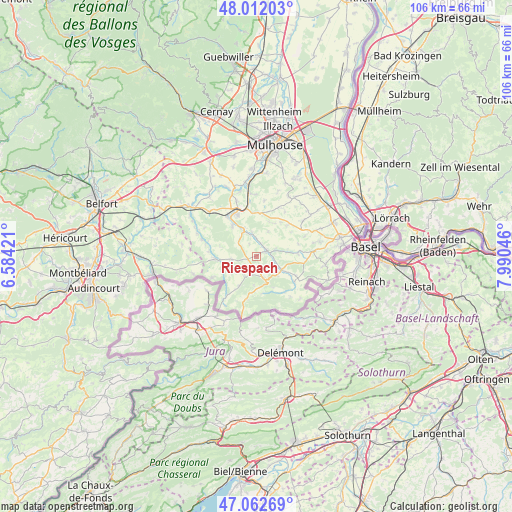
Riespach GPS coordinates[2]
47° 32' 22.236" North, 7° 17' 14.388" East
| Map corner | latitude | longitude |
|---|---|---|
| Upper-left | 48.01203°, | 6.58421° |
| Center: | 47.53951°, | 7.28733° |
| Lower-right: | 47.06269°, | 7.99046° |
| Map W x H: | 105.6×105.6 km | = 65.6×65.6mi |
| max Lat: | 51.07786° ⇑48.2% North |
| Riespach: | 47.53951° |
| min Lat: | ⇓51.8% South 41.3874° |
| min Long | Riespach | max Long |
| -5.08615° | 7.28733° | 9.52242° |
| W 96.4%⇐ | ⇒3.6% E |
Elevation
Elevation of Riespach is 402 m = 1319 ft, and this is 208.3 m = 683 ft above average elevation for this country.
| Max E: |
2333 m = 7654 ft | 11.3% |
| Riespach | 402 m 1319 ft | |
| Avg. | 193.7 m = 635 ft | |
Min E: |
-1 m = -3 ft | 88.7% |
See also: France elevation on elevation.city.
Geographical zone
Riespach is located in North temperate zone (between Tropic of Cancer and the Arctic Circle). Distance of this North polar circle is 2115.3 km =1314.4 mi to North.| Distance of | km | miles | from Riespach |
|---|---|---|---|
| North Pole | 4721.2 | 2933.6 | to North |
| Arctic Circle | 2115.3 | 1314.4 | to North |
| Tropic Cancer | 2680 | 1665.3 | to South |
| Equator | 5285.9 | 3284.5 | to South |


Nearby cities:
15 places around Riespach: (largest is in red/bold)
• Bisel
5.2 km =3.2 mi,  264°
264°
• Durlinsdorf
7 km =4.3 mi,  210°
210°
• Durmenach
4.1 km =2.5 mi,  107°
107°
• Ferrette
5.4 km =3.4 mi,  158°
158°
• Grentzingen
2.9 km =1.8 mi,  18°
18°
• Heimersdorf
5 km =3.1 mi,  316°
316°
• Hirsingue
5.9 km =3.7 mi,  334°
334°
• Hirtzbach
8.2 km =5.1 mi, 323°
• Mœrnach
5.2 km =3.2 mi, 212°
• Oberdorf
2.6 km =1.6 mi,  32°
32°
• Roppentzwiller
3.3 km =2.1 mi,  87°
87°
• Steinsoultz
4 km =2.5 mi,  70°
70°
• Vieux-Ferrette
4.2 km =2.6 mi,  165°
165°
• Waldighofen
2.4 km =1.5 mi,  59°
59°
• Werentzhouse
5.6 km =3.5 mi,  115°
115°
Sources, notices
• [Note1] Compared only with cities in France existing in our database
• [Src1] Map data: © OpenStreetMap contributors (CC-BY-SA)
• [Src2] Other city data from geonames.org with taken over terms of usage.
• [Src3] Geographical zone / Annual Mean Temperature by Robert A. Rohde @ Wikipedia
