Waldighofen geodata
Waldighofen (Grand Est) is a populated place; located in France in Europe/Paris (GMT+2) time zone. With population of 1,240 people, there are 7330 cities with bigger population in this country. Compared to other cities in France, 52% of cities are located further ↓South; 96.7% of cities are located further ←West and 88% of cities have lower elevation than Waldighofen. Note1
Administrative division(s):
- Level 1: Grand Est
- Level 2: Haut-Rhin
- Level 3: Altkirch
- Level 4: Waldighofen


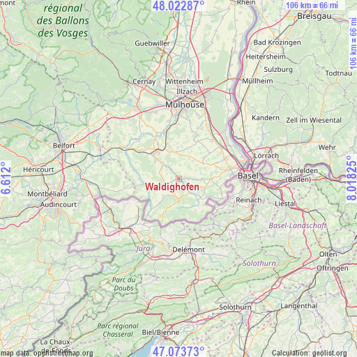
Waldighofen GPS coordinates[2]
47° 33' 1.62" North, 7° 18' 54.432" East
| Map corner | latitude | longitude |
|---|---|---|
| Upper-left | 48.02287°, | 6.612° |
| Center: | 47.55045°, | 7.31512° |
| Lower-right: | 47.07373°, | 8.01825° |
| Map W x H: | 105.5×105.5 km | = 65.6×65.6mi |
| max Lat: | 51.07786° ⇑48% North |
| Waldighofen: | 47.55045° |
| min Lat: | ⇓52% South 41.3874° |
| min Long | Waldighofen | max Long |
| -5.08615° | 7.31512° | 9.52242° |
| W 96.7%⇐ | ⇒3.3% E |
Elevation
Elevation of Waldighofen is 389 m = 1276 ft, and this is 195.3 m = 641 ft above average elevation for this country.
| Max E: |
2333 m = 7654 ft | 12% |
| Waldighofen | 389 m 1276 ft | |
| Avg. | 193.7 m = 635 ft | |
Min E: |
-1 m = -3 ft | 88% |
See also: France elevation on elevation.city.
Geographical zone
Waldighofen is located in North temperate zone (between Tropic of Cancer and the Arctic Circle). Distance of this North polar circle is 2114.1 km =1313.6 mi to North.| Distance of | km | miles | from Waldighofen |
|---|---|---|---|
| North Pole | 4719.9 | 2932.8 | to North |
| Arctic Circle | 2114.1 | 1313.6 | to North |
| Tropic Cancer | 2681.2 | 1666 | to South |
| Equator | 5287.1 | 3285.3 | to South |


Nearby cities:
15 places around Waldighofen: (largest is in red/bold)
• Bisel
7.5 km =4.7 mi,  256°
256°
• Durmenach
3 km =1.9 mi,  143°
143°
• Ferrette
6.2 km =3.9 mi,  180°
180°
• Grentzingen
1.9 km =1.2 mi,  322°
322°
• Heimersdorf
6 km =3.7 mi,  293°
293°
• Hirsingue
6.2 km =3.9 mi,  311°
311°
• Jettingen
6.9 km =4.3 mi,  38°
38°
• Muespach-le-Haut
6.5 km =4 mi,  93°
93°
• Mœrnach
7.4 km =4.6 mi,  221°
221°
• Oberdorf
1.2 km =0.7 mi,  325°
325°
• Riespach
2.4 km =1.5 mi,  239°
239°
• Roppentzwiller
1.6 km =1 mi,  132°
132°
• Steinsoultz
1.7 km =1.1 mi, 85°
• Vieux-Ferrette
5.4 km =3.4 mi,  190°
190°
• Werentzhouse
4.7 km =2.9 mi, 140°
Sources, notices
• [Note1] Compared only with cities in France existing in our database
• [Src1] Map data: © OpenStreetMap contributors (CC-BY-SA)
• [Src2] Other city data from geonames.org with taken over terms of usage.
• [Src3] Geographical zone / Annual Mean Temperature by Robert A. Rohde @ Wikipedia
