Estang geodata
Estang (Occitanie) is a populated place; located in France in Europe/Paris (GMT+2) time zone. With population of 674 people, there are 12156 cities with bigger population in this country. Compared to other cities in France, 88.4% of cities are located further ↑North; 78.9% of cities are located further →East and 59.4% of cities have higher elevation than Estang. Note1
Administrative division(s):
- Level 1: Occitanie
- Level 2: Gers
- Level 3: Arrondissement de Condom
- Level 4: Estang


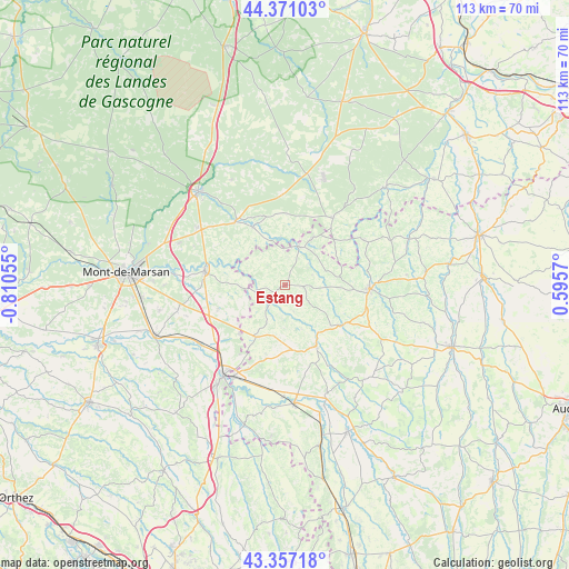
Estang GPS coordinates[2]
43° 51' 58.536" North, 0° 6' 26.748" West
| Map corner | latitude | longitude |
|---|---|---|
| Upper-left | 44.37103°, | -0.81055° |
| Center: | 43.86626°, | -0.10743° |
| Lower-right: | 43.35718°, | 0.5957° |
| Map W x H: | 112.7×112.7 km | = 70×70mi |
| max Lat: | 51.07786° ⇑88.4% North |
| Estang: | 43.86626° |
| min Lat: | ⇓11.6% South 41.3874° |
| min Long | Estang | max Long |
| -5.08615° | -0.10743° | 9.52242° |
| W 21.1%⇐ | ⇒78.9% E |
Elevation
Elevation of Estang is 104 m = 341 ft, and this is 89.7 m = 294 ft below average elevation for this country.
| Max E: |
2333 m = 7654 ft | 59.4% |
| Avg. | 193.7 m = 635 ft | |
| Estang | 104 m = 341 ft | |
Min E: |
-1 m = -3 ft | 40.6% |
See also: France elevation on elevation.city.
Geographical zone
Estang is located in North temperate zone (between Tropic of Cancer and the Arctic Circle). Distance of this Northern Tropic circle is 2271.6 km =1411.5 mi to South.| Distance of | km | miles | from Estang |
|---|---|---|---|
| North Pole | 5129.6 | 3187.4 | to North |
| Arctic Circle | 2523.7 | 1568.2 | to North |
| Tropic Cancer | 2271.6 | 1411.5 | to South |
| Equator | 4877.5 | 3030.7 | to South |


Nearby cities:
15 places around Estang: (largest is in red/bold)
• Barcelonne-du-Gers
20.8 km =12.9 mi,  209°
209°
• Cazaubon
8.2 km =5.1 mi,  22°
22°
• Cazères-sur-l’Adour
20.4 km =12.7 mi,  235°
235°
• Eauze
16.8 km =10.4 mi,  92°
92°
• Gabarret
16.5 km =10.3 mi,  34°
34°
• Hontanx
14.1 km =8.8 mi,  250°
250°
• Labastide-d’Armagnac
13.1 km =8.1 mi,  331°
331°
• Le Houga
11.7 km =7.3 mi, 209°
• Manciet
14.1 km =8.8 mi,  121°
121°
• Nogaro
13.4 km =8.3 mi,  153°
153°
• Parleboscq
11.4 km =7.1 mi,  49°
49°
• Pouydesseaux
20.8 km =12.9 mi,  303°
303°
• Pujo-le-Plan
17.9 km =11.1 mi,  266°
266°
• Saint-Justin
16.1 km =10 mi,  321°
321°
• Villeneuve-de-Marsan
16.4 km =10.2 mi,  278°
278°
Sources, notices
• [Note1] Compared only with cities in France existing in our database
• [Src1] Map data: © OpenStreetMap contributors (CC-BY-SA)
• [Src2] Other city data from geonames.org with taken over terms of usage.
• [Src3] Geographical zone / Annual Mean Temperature by Robert A. Rohde @ Wikipedia
