Nogaro geodata
Nogaro (Occitanie) is a populated place; located in France in Europe/Paris (GMT+2) time zone. With population of 2,120 people, there are 4545 cities with bigger population in this country. Compared to other cities in France, 89.6% of cities are located further ↑North; 78.3% of cities are located further →East and 58.3% of cities have higher elevation than Nogaro. Note1
Administrative division(s):
- Level 1: Occitanie
- Level 2: Gers
- Level 3: Arrondissement de Condom
- Level 4: Nogaro


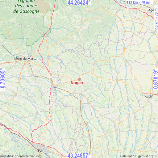
Nogaro GPS coordinates[2]
43° 45' 30.816" North, 0° 1' 58.548" West
| Map corner | latitude | longitude |
|---|---|---|
| Upper-left | 44.26424°, | -0.73605° |
| Center: | 43.75856°, | -0.03293° |
| Lower-right: | 43.24857°, | 0.67019° |
| Map W x H: | 112.9×112.9 km | = 70.2×70.2mi |
| max Lat: | 51.07786° ⇑89.6% North |
| Nogaro: | 43.75856° |
| min Lat: | ⇓10.4% South 41.3874° |
| min Long | Nogaro | max Long |
| -5.08615° | -0.03293° | 9.52242° |
| W 21.7%⇐ | ⇒78.3% E |
Elevation
Elevation of Nogaro is 107 m = 351 ft, and this is 86.7 m = 284 ft below average elevation for this country.
| Max E: |
2333 m = 7654 ft | 58.3% |
| Avg. | 193.7 m = 635 ft | |
| Nogaro | 107 m = 351 ft | |
Min E: |
-1 m = -3 ft | 41.7% |
See also: France elevation on elevation.city.
Geographical zone
Nogaro is located in North temperate zone (between Tropic of Cancer and the Arctic Circle). Distance of this Northern Tropic circle is 2259.6 km =1404 mi to South.| Distance of | km | miles | from Nogaro |
|---|---|---|---|
| North Pole | 5141.6 | 3194.8 | to North |
| Arctic Circle | 2535.7 | 1575.6 | to North |
| Tropic Cancer | 2259.6 | 1404 | to South |
| Equator | 4865.5 | 3023.3 | to South |


Nearby cities:
15 places around Nogaro: (largest is in red/bold)
• Aignan
11.6 km =7.2 mi,  125°
125°
• Barcelonne-du-Gers
17.4 km =10.8 mi,  249°
249°
• Beaumarchés
21.6 km =13.4 mi,  154°
154°
• Castelnau-Rivière-Basse
19.7 km =12.2 mi,  178°
178°
• Cazaubon
19.7 km =12.2 mi,  351°
351°
• Eauze
15.7 km =9.8 mi,  43°
43°
• Estang
13.4 km =8.3 mi,  333°
333°
• Hontanx
20.7 km =12.9 mi,  290°
290°
• Lannepax
21.4 km =13.3 mi,  77°
77°
• Le Houga
11.8 km =7.3 mi,  278°
278°
• Manciet
7.7 km =4.8 mi,  52°
52°
• Parleboscq
19.6 km =12.2 mi,  7°
7°
• Plaisance
18.3 km =11.4 mi,  159°
159°
• Riscle
12.1 km =7.5 mi,  200°
200°
• Viella
19.7 km =12.2 mi,  205°
205°
Sources, notices
• [Note1] Compared only with cities in France existing in our database
• [Src1] Map data: © OpenStreetMap contributors (CC-BY-SA)
• [Src2] Other city data from geonames.org with taken over terms of usage.
• [Src3] Geographical zone / Annual Mean Temperature by Robert A. Rohde @ Wikipedia
