Manciet geodata
Manciet (Occitanie) is a populated place; located in France in Europe/Paris (GMT+2) time zone. With population of 802 people, there are 10583 cities with bigger population in this country. Compared to other cities in France, 89.1% of cities are located further ↑North; 77.8% of cities are located further →East and 53.3% of cities have lower elevation than Manciet. Note1
Administrative division(s):
- Level 1: Occitanie
- Level 2: Gers
- Level 3: Arrondissement de Condom
- Level 4: Manciet


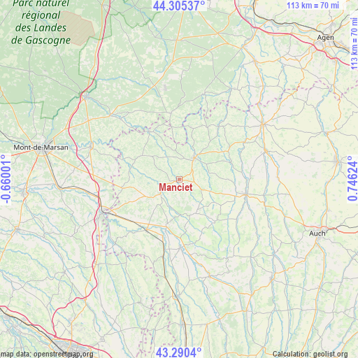
Manciet GPS coordinates[2]
43° 48' 0.144" North, 0° 2' 35.196" East
| Map corner | latitude | longitude |
|---|---|---|
| Upper-left | 44.30537°, | -0.66001° |
| Center: | 43.80004°, | 0.04311° |
| Lower-right: | 43.2904°, | 0.74624° |
| Map W x H: | 112.9×112.9 km | = 70.2×70.2mi |
| max Lat: | 51.07786° ⇑89.1% North |
| Manciet: | 43.80004° |
| min Lat: | ⇓10.9% South 41.3874° |
| min Long | Manciet | max Long |
| -5.08615° | 0.04311° | 9.52242° |
| W 22.2%⇐ | ⇒77.8% E |
Elevation
Elevation of Manciet is 144 m = 472 ft, and this is 49.7 m = 163 ft below average elevation for this country.
| Max E: |
2333 m = 7654 ft | 46.7% |
| Avg. | 193.7 m = 635 ft | |
| Manciet | 144 m = 472 ft | |
Min E: |
-1 m = -3 ft | 53.3% |
See also: France elevation on elevation.city.
Geographical zone
Manciet is located in North temperate zone (between Tropic of Cancer and the Arctic Circle). Distance of this Northern Tropic circle is 2264.2 km =1406.9 mi to South.| Distance of | km | miles | from Manciet |
|---|---|---|---|
| North Pole | 5137 | 3192 | to North |
| Arctic Circle | 2531.1 | 1572.8 | to North |
| Tropic Cancer | 2264.2 | 1406.9 | to South |
| Equator | 4870.1 | 3026.1 | to South |


Nearby cities:
15 places around Manciet: (largest is in red/bold)
• Aignan
11.8 km =7.3 mi,  163°
163°
• Beaumarchés
24.3 km =15.1 mi,  172°
172°
• Cazaubon
17.4 km =10.8 mi,  329°
329°
• Eauze
8.2 km =5.1 mi,  35°
35°
• Estang
14.1 km =8.8 mi,  301°
301°
• Gabarret
21 km =13 mi,  352°
352°
• Gondrin
18.2 km =11.3 mi,  58°
58°
• Lannepax
14.8 km =9.2 mi,  89°
89°
• Le Houga
18 km =11.2 mi,  260°
260°
• Montréal
21.1 km =13.1 mi, 37°
• Nogaro
7.7 km =4.8 mi,  232°
232°
• Parleboscq
15.2 km =9.4 mi, 346°
• Plaisance
21.8 km =13.5 mi,  179°
179°
• Riscle
19.1 km =11.9 mi,  213°
213°
• Vic-Fezensac
21.9 km =13.6 mi,  98°
98°
Sources, notices
• [Note1] Compared only with cities in France existing in our database
• [Src1] Map data: © OpenStreetMap contributors (CC-BY-SA)
• [Src2] Other city data from geonames.org with taken over terms of usage.
• [Src3] Geographical zone / Annual Mean Temperature by Robert A. Rohde @ Wikipedia
