Jarzé geodata
Jarzé (Pays de la Loire) is a populated place; located in France in Europe/Paris (GMT+2) time zone. With population of 1,468 people, there are 6303 cities with bigger population in this country. Compared to other cities in France, 52.1% of cities are located further ↓South; 79.9% of cities are located further →East and 75.8% of cities have higher elevation than Jarzé. Note1
Administrative division(s):
- Level 1: Pays de la Loire
- Level 2: Département de Maine-et-Loire
- Level 3: Angers
- Level 4: Jarzé Villages


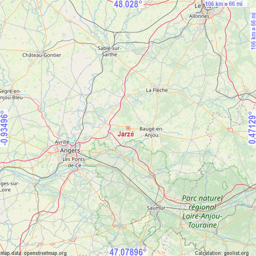
Jarzé GPS coordinates[2]
47° 33' 20.268" North, 0° 13' 54.588" West
| Map corner | latitude | longitude |
|---|---|---|
| Upper-left | 48.028°, | -0.93496° |
| Center: | 47.55563°, | -0.23183° |
| Lower-right: | 47.07896°, | 0.47129° |
| Map W x H: | 105.5×105.5 km | = 65.6×65.6mi |
| max Lat: | 51.07786° ⇑47.9% North |
| Jarzé: | 47.55563° |
| min Lat: | ⇓52.1% South 41.3874° |
| min Long | Jarzé | max Long |
| -5.08615° | -0.23183° | 9.52242° |
| W 20.1%⇐ | ⇒79.9% E |
Elevation
Elevation of Jarzé is 65 m = 213 ft, and this is 128.7 m = 422 ft below average elevation for this country.
| Max E: |
2333 m = 7654 ft | 75.8% |
| Avg. | 193.7 m = 635 ft | |
| Jarzé | 65 m = 213 ft | |
Min E: |
-1 m = -3 ft | 24.2% |
See also: France elevation on elevation.city.
Geographical zone
Jarzé is located in North temperate zone (between Tropic of Cancer and the Arctic Circle). Distance of this North polar circle is 2113.5 km =1313.3 mi to North.| Distance of | km | miles | from Jarzé |
|---|---|---|---|
| North Pole | 4719.4 | 2932.5 | to North |
| Arctic Circle | 2113.5 | 1313.3 | to North |
| Tropic Cancer | 2681.8 | 1666.4 | to South |
| Equator | 5287.7 | 3285.6 | to South |


Nearby cities:
15 places around Jarzé: (largest is in red/bold)
• Baugé-en-Anjou
9.5 km =5.9 mi,  97°
97°
• Bauné
9 km =5.6 mi,  226°
226°
• Beaufort-en-Vallée
12.9 km =8 mi,  175°
175°
• Bocé
12.5 km =7.8 mi,  115°
115°
• Cheviré-le-Rouge
5.8 km =3.6 mi,  41°
41°
• Corné
12.9 km =8 mi,  223°
223°
• Corzé
11.9 km =7.4 mi,  272°
272°
• Fontaine-Guérin
8.3 km =5.2 mi,  157°
157°
• Fougeré
10.2 km =6.3 mi, 37°
• Le Vieil-Baugé
8.9 km =5.5 mi,  107°
107°
• Les Rairies
10.8 km =6.7 mi,  10°
10°
• Lézigné
10.2 km =6.3 mi,  331°
331°
• Mazé
11.4 km =7.1 mi,  194°
194°
• Sarrigné
12.8 km =8 mi,  242°
242°
• Seiches-sur-le-Loir
9.5 km =5.9 mi,  282°
282°
Sources, notices
• [Note1] Compared only with cities in France existing in our database
• [Src1] Map data: © OpenStreetMap contributors (CC-BY-SA)
• [Src2] Other city data from geonames.org with taken over terms of usage.
• [Src3] Geographical zone / Annual Mean Temperature by Robert A. Rohde @ Wikipedia
