Dun-le-Palestel geodata
Dun-le-Palestel (Nouvelle-Aquitaine) is a populated place; located in France in Europe/Paris (GMT+2) time zone. With population of 1,125 people, there are 7976 cities with bigger population in this country. Compared to other cities in France, 62.2% of cities are located further ↑North; 60.8% of cities are located further →East and 86.7% of cities have lower elevation than Dun-le-Palestel. Note1
Administrative division(s):
- Level 1: Nouvelle-Aquitaine
- Level 2: Creuse
- Level 3: Arrondissement de Guéret
- Level 4: Dun-le-Palestel


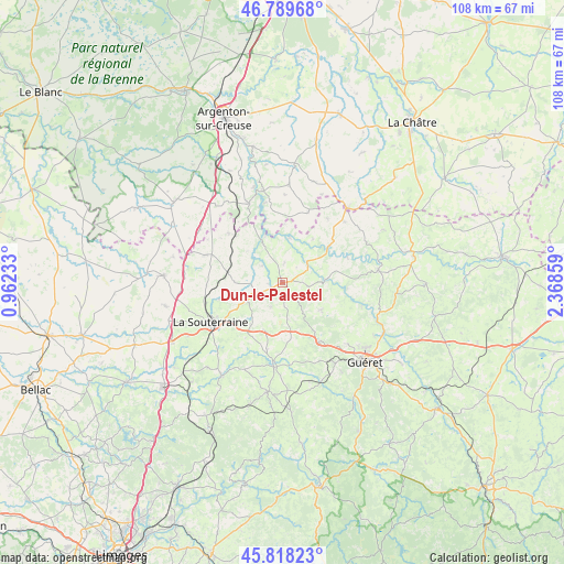
Dun-le-Palestel GPS coordinates[2]
46° 18' 21.996" North, 1° 39' 55.656" East
| Map corner | latitude | longitude |
|---|---|---|
| Upper-left | 46.78968°, | 0.96233° |
| Center: | 46.30611°, | 1.66546° |
| Lower-right: | 45.81823°, | 2.36859° |
| Map W x H: | 108×108 km | = 67.1×67.1mi |
| max Lat: | 51.07786° ⇑62.2% North |
| Dun-le-Palestel: | 46.30611° |
| min Lat: | ⇓37.8% South 41.3874° |
| min Long | Dun-le-Palestel | max Long |
| -5.08615° | 1.66546° | 9.52242° |
| W 39.2%⇐ | ⇒60.8% E |
Elevation
Elevation of Dun-le-Palestel is 370 m = 1214 ft, and this is 176.3 m = 578 ft above average elevation for this country.
| Max E: |
2333 m = 7654 ft | 13.3% |
| Dun-le-Palestel | 370 m 1214 ft | |
| Avg. | 193.7 m = 635 ft | |
Min E: |
-1 m = -3 ft | 86.7% |
See also: France elevation on elevation.city.
Geographical zone
Dun-le-Palestel is located in North temperate zone (between Tropic of Cancer and the Arctic Circle). Distance of this North polar circle is 2252.4 km =1399.6 mi to North.| Distance of | km | miles | from Dun-le-Palestel |
|---|---|---|---|
| North Pole | 4858.3 | 3018.8 | to North |
| Arctic Circle | 2252.4 | 1399.6 | to North |
| Tropic Cancer | 2542.8 | 1580 | to South |
| Equator | 5148.8 | 3199.3 | to South |


Nearby cities:
15 places around Dun-le-Palestel: (largest is in red/bold)
• Azerables
15.6 km =9.7 mi,  289°
289°
• Bussière-Dunoise
9.1 km =5.7 mi,  125°
125°
• Chantôme
14.3 km =8.9 mi,  324°
324°
• Chéniers
13.4 km =8.3 mi,  68°
68°
• Crozant
10.1 km =6.3 mi,  340°
340°
• Fresselines
8.6 km =5.3 mi,  8°
8°
• La Celle-Dunoise
8.1 km =5 mi,  88°
88°
• La Souterraine
15.7 km =9.8 mi,  241°
241°
• Méasnes
15 km =9.3 mi,  35°
35°
• Naillat
5.1 km =3.2 mi,  205°
205°
• Saint-Agnant-de-Versillat
12.3 km =7.6 mi,  255°
255°
• Saint-Priest-la-Feuille
15.4 km =9.6 mi,  220°
220°
• Saint-Sulpice-le-Dunois
5 km =3.1 mi,  98°
98°
• Saint-Sébastien
14 km =8.7 mi,  312°
312°
• Saint-Vaury
13.3 km =8.3 mi,  148°
148°
Sources, notices
• [Note1] Compared only with cities in France existing in our database
• [Src1] Map data: © OpenStreetMap contributors (CC-BY-SA)
• [Src2] Other city data from geonames.org with taken over terms of usage.
• [Src3] Geographical zone / Annual Mean Temperature by Robert A. Rohde @ Wikipedia
