Saint-Sulpice-le-Dunois geodata
Saint-Sulpice-le-Dunois (Nouvelle-Aquitaine) is a populated place; located in France in Europe/Paris (GMT+2) time zone. With population of 642 people, there are 12644 cities with bigger population in this country. Compared to other cities in France, 62.3% of cities are located further ↑North; 60.2% of cities are located further →East and 84.3% of cities have lower elevation than Saint-Sulpice-le-Dunois. Note1
Administrative division(s):
- Level 1: Nouvelle-Aquitaine
- Level 2: Creuse
- Level 3: Arrondissement de Guéret
- Level 4: Saint-Sulpice-le-Dunois
Current local time in Saint-Sulpice-le-Dunois:
03:15 PM, WednesdayDifference from your time zone: hours


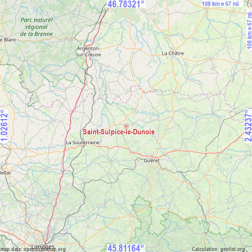
Saint-Sulpice-le-Dunois GPS coordinates[2]
46° 17' 58.488" North, 1° 43' 45.264" East
| Map corner | latitude | longitude |
|---|---|---|
| Upper-left | 46.78321°, | 1.02612° |
| Center: | 46.29958°, | 1.72924° |
| Lower-right: | 45.81164°, | 2.43237° |
| Map W x H: | 108×108 km | = 67.1×67.1mi |
| max Lat: | 51.07786° ⇑62.3% North |
| Saint-Sulpice-le-Dunois: | 46.29958° |
| min Lat: | ⇓37.7% South 41.3874° |
| min Long | Saint-Sulpice-l | max Long |
| -5.08615° | 1.72924° | 9.52242° |
| W 39.8%⇐ | ⇒60.2% E |
Elevation
Elevation of Saint-Sulpice-le-Dunois is 339 m = 1112 ft, and this is 145.3 m = 477 ft above average elevation for this country.
| Max E: |
2333 m = 7654 ft | 15.7% |
| Saint-Sulpice-le-Dunois | 339 m 1112 ft | |
| Avg. | 193.7 m = 635 ft | |
Min E: |
-1 m = -3 ft | 84.3% |
See also: France elevation on elevation.city.
Geographical zone
Saint-Sulpice-le-Dunois is located in North temperate zone (between Tropic of Cancer and the Arctic Circle). Distance of this North polar circle is 2253.1 km =1400 mi to North.| Distance of | km | miles | from Saint-Sulpice-le-Dunois |
|---|---|---|---|
| North Pole | 4859 | 3019.2 | to North |
| Arctic Circle | 2253.1 | 1400 | to North |
| Tropic Cancer | 2542.1 | 1579.6 | to South |
| Equator | 5148 | 3198.8 | to South |


Nearby cities:
15 places around Saint-Sulpice-le-Dunois: (largest is in red/bold)
• Aigurande
16.8 km =10.4 mi,  27°
27°
• Anzême
11 km =6.8 mi,  109°
109°
• Bonnat
13.8 km =8.6 mi,  76°
76°
• Bussière-Dunoise
5.2 km =3.2 mi,  150°
150°
• Chéniers
9.5 km =5.9 mi,  52°
52°
• Crozant
13.2 km =8.2 mi,  321°
321°
• Dun-le-Palestel
5 km =3.1 mi,  278°
278°
• Fresselines
9.9 km =6.2 mi,  338°
338°
• La Celle-Dunoise
3.4 km =2.1 mi,  72°
72°
• Lourdoueix-Saint-Pierre
14.1 km =8.8 mi, 30°
• Méasnes
13.5 km =8.4 mi,  15°
15°
• Naillat
8.1 km =5 mi,  241°
241°
• Saint-Fiel
15.9 km =9.9 mi,  126°
126°
• Saint-Sulpice-le-Guérétois
13.4 km =8.3 mi, 145°
• Saint-Vaury
10.8 km =6.7 mi,  169°
169°
Sources, notices
• [Note1] Compared only with cities in France existing in our database
• [Src1] Map data: © OpenStreetMap contributors (CC-BY-SA)
• [Src2] Other city data from geonames.org with taken over terms of usage.
• [Src3] Geographical zone / Annual Mean Temperature by Robert A. Rohde @ Wikipedia
