Valhuon geodata
Valhuon (Hauts-de-France) is a populated place; located in France in Europe/Paris (GMT+2) time zone. With population of 525 people, there are 14719 cities with bigger population in this country. Compared to other cities in France, 96.7% of cities are located further ↓South; 51.4% of cities are located further →East and 57.4% of cities have lower elevation than Valhuon. Note1
Administrative division(s):
- Level 1: Hauts-de-France
- Level 2: Pas-de-Calais
- Level 3: Arras
- Level 4: Valhuon


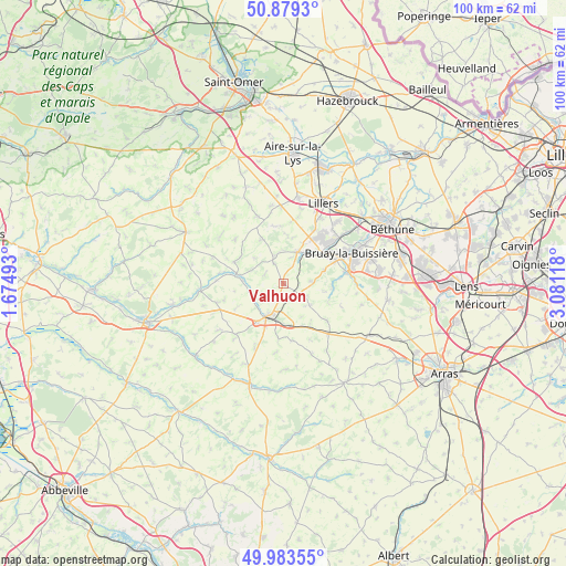
Valhuon GPS coordinates[2]
50° 26' 0.744" North, 2° 22' 40.98" East
| Map corner | latitude | longitude |
|---|---|---|
| Upper-left | 50.8793°, | 1.67493° |
| Center: | 50.43354°, | 2.37805° |
| Lower-right: | 49.98355°, | 3.08118° |
| Map W x H: | 99.6×99.6 km | = 61.9×61.9mi |
| max Lat: | 51.07786° ⇑3.3% North |
| Valhuon: | 50.43354° |
| min Lat: | ⇓96.7% South 41.3874° |
| min Long | Valhuon | max Long |
| -5.08615° | 2.37805° | 9.52242° |
| W 48.6%⇐ | ⇒51.4% E |
Elevation
Elevation of Valhuon is 159 m = 522 ft, and this is 34.7 m = 114 ft below average elevation for this country.
| Max E: |
2333 m = 7654 ft | 42.6% |
| Avg. | 193.7 m = 635 ft | |
| Valhuon | 159 m = 522 ft | |
Min E: |
-1 m = -3 ft | 57.4% |
See also: France elevation on elevation.city.
Geographical zone
Valhuon is located in North temperate zone (between Tropic of Cancer and the Arctic Circle). Distance of this North polar circle is 1793.5 km =1114.4 mi to North.| Distance of | km | miles | from Valhuon |
|---|---|---|---|
| North Pole | 4399.4 | 2733.7 | to North |
| Arctic Circle | 1793.5 | 1114.4 | to North |
| Tropic Cancer | 3001.8 | 1865.2 | to South |
| Equator | 5607.7 | 3484.5 | to South |


Nearby cities:
15 places around Valhuon: (largest is in red/bold)
• Anvin
8.9 km =5.5 mi,  279°
279°
• Bours
3.1 km =1.9 mi,  44°
44°
• Calonne-Ricouart
8.8 km =5.5 mi,  49°
49°
• Camblain-Châtelain
7.8 km =4.8 mi, 44°
• Cauchy-à-la-Tour
9.2 km =5.7 mi,  31°
31°
• Diéval
5.1 km =3.2 mi,  87°
87°
• Floringhem
7.7 km =4.8 mi, 25°
• Gauchin-Verloingt
6.3 km =3.9 mi,  228°
228°
• Heuchin
9 km =5.6 mi,  301°
301°
• La Comté
8.1 km =5 mi,  96°
96°
• Magnicourt-en-Comte
9.4 km =5.8 mi,  113°
113°
• Ourton
7.8 km =4.8 mi,  70°
70°
• Pernes
6.2 km =3.9 mi,  23°
23°
• Roëllecourt
7.3 km =4.5 mi,  175°
175°
• Saint-Pol-sur-Ternoise
6.6 km =4.1 mi,  208°
208°
Sources, notices
• [Note1] Compared only with cities in France existing in our database
• [Src1] Map data: © OpenStreetMap contributors (CC-BY-SA)
• [Src2] Other city data from geonames.org with taken over terms of usage.
• [Src3] Geographical zone / Annual Mean Temperature by Robert A. Rohde @ Wikipedia
