Cudos geodata
Cudos (Nouvelle-Aquitaine) is a populated place; located in France in Europe/Paris (GMT+2) time zone. With population of 729 people, there are 11423 cities with bigger population in this country. Compared to other cities in France, 84.4% of cities are located further ↑North; 79.9% of cities are located further →East and 57.3% of cities have higher elevation than Cudos. Note1
Administrative division(s):
- Level 1: Nouvelle-Aquitaine
- Level 2: Gironde
- Level 3: Arrondissement de Langon
- Level 4: Cudos


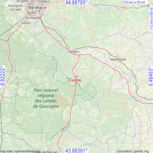
Cudos GPS coordinates[2]
44° 23' 15.504" North, 0° 13' 8.76" West
| Map corner | latitude | longitude |
|---|---|---|
| Upper-left | 44.88795°, | -0.92222° |
| Center: | 44.38764°, | -0.2191° |
| Lower-right: | 43.88301°, | 0.48403° |
| Map W x H: | 111.7×111.7 km | = 69.4×69.4mi |
| max Lat: | 51.07786° ⇑84.4% North |
| Cudos: | 44.38764° |
| min Lat: | ⇓15.6% South 41.3874° |
| min Long | Cudos | max Long |
| -5.08615° | -0.2191° | 9.52242° |
| W 20.1%⇐ | ⇒79.9% E |
Elevation
Elevation of Cudos is 110 m = 361 ft, and this is 83.7 m = 275 ft below average elevation for this country.
| Max E: |
2333 m = 7654 ft | 57.3% |
| Avg. | 193.7 m = 635 ft | |
| Cudos | 110 m = 361 ft | |
Min E: |
-1 m = -3 ft | 42.7% |
See also: France elevation on elevation.city.
Geographical zone
Cudos is located in North temperate zone (between Tropic of Cancer and the Arctic Circle). Distance of this Northern Tropic circle is 2329.5 km =1447.5 mi to South.| Distance of | km | miles | from Cudos |
|---|---|---|---|
| North Pole | 5071.6 | 3151.3 | to North |
| Arctic Circle | 2465.7 | 1532.1 | to North |
| Tropic Cancer | 2329.5 | 1447.5 | to South |
| Equator | 4935.4 | 3066.7 | to South |


Nearby cities:
15 places around Cudos: (largest is in red/bold)
• Aillas
15 km =9.3 mi,  50°
50°
• Auros
13.3 km =8.3 mi,  26°
26°
• Bazas
5 km =3.1 mi,  5°
5°
• Captieux
11.1 km =6.9 mi,  197°
197°
• Coimères
12.1 km =7.5 mi,  3°
3°
• Grignols
14 km =8.7 mi,  89°
89°
• Langon
18.6 km =11.6 mi,  352°
352°
• Léogeats
18.1 km =11.2 mi,  319°
319°
• Mazères
12.3 km =7.6 mi, 345°
• Noaillan
15.6 km =9.7 mi,  311°
311°
• Préchac
10.8 km =6.7 mi,  276°
276°
• Roaillan
13.3 km =8.3 mi,  337°
337°
• Sauternes
18.9 km =11.7 mi,  328°
328°
• Savignac
17.4 km =10.8 mi, 30°
• Villandraut
14.4 km =8.9 mi,  302°
302°
Sources, notices
• [Note1] Compared only with cities in France existing in our database
• [Src1] Map data: © OpenStreetMap contributors (CC-BY-SA)
• [Src2] Other city data from geonames.org with taken over terms of usage.
• [Src3] Geographical zone / Annual Mean Temperature by Robert A. Rohde @ Wikipedia
