Courniou geodata
Courniou (Occitanie) is a populated place; located in France in Europe/Paris (GMT+2) time zone. With population of 688 people, there are 11973 cities with bigger population in this country. Compared to other cities in France, 93.4% of cities are located further ↑North; 53.7% of cities are located further ←West and 86.9% of cities have lower elevation than Courniou. Note1
Administrative division(s):
- Level 1: Occitanie
- Level 2: Département de l'Hérault
- Level 3: Arrondissement de Béziers
- Level 4: Courniou


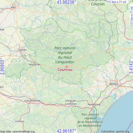
Courniou GPS coordinates[2]
43° 28' 27.372" North, 2° 42' 40.212" East
| Map corner | latitude | longitude |
|---|---|---|
| Upper-left | 43.98236°, | 2.00805° |
| Center: | 43.47427°, | 2.71117° |
| Lower-right: | 42.96187°, | 3.4143° |
| Map W x H: | 113.5×113.5 km | = 70.5×70.5mi |
| max Lat: | 51.07786° ⇑93.4% North |
| Courniou: | 43.47427° |
| min Lat: | ⇓6.6% South 41.3874° |
| min Long | Courniou | max Long |
| -5.08615° | 2.71117° | 9.52242° |
| W 53.7%⇐ | ⇒46.3% E |
Elevation
Elevation of Courniou is 372 m = 1220 ft, and this is 178.3 m = 585 ft above average elevation for this country.
| Max E: |
2333 m = 7654 ft | 13.1% |
| Courniou | 372 m 1220 ft | |
| Avg. | 193.7 m = 635 ft | |
Min E: |
-1 m = -3 ft | 86.9% |
See also: France elevation on elevation.city.
Geographical zone
Courniou is located in North temperate zone (between Tropic of Cancer and the Arctic Circle). Distance of this Northern Tropic circle is 2228 km =1384.4 mi to South.| Distance of | km | miles | from Courniou |
|---|---|---|---|
| North Pole | 5173.2 | 3214.5 | to North |
| Arctic Circle | 2567.3 | 1595.2 | to North |
| Tropic Cancer | 2228 | 1384.4 | to South |
| Equator | 4833.9 | 3003.6 | to South |


Nearby cities:
15 places around Courniou: (largest is in red/bold)
• Albine
13.9 km =8.6 mi,  262°
262°
• Anglès
15.6 km =9.7 mi,  309°
309°
• Bize-Minervois
21.8 km =13.5 mi,  143°
143°
• La Livinière
18.6 km =11.6 mi,  199°
199°
• La Salvetat-sur-Agout
14 km =8.7 mi,  1°
1°
• Labastide-Rouairoux
5.8 km =3.6 mi,  271°
271°
• Olargues
18.8 km =11.7 mi,  60°
60°
• Olonzac
21.3 km =13.2 mi,  175°
175°
• Pépieux
19.8 km =12.3 mi,  187°
187°
• Riols
7.4 km =4.6 mi, 63°
• Saint-Amans-Soult
17.8 km =11.1 mi, 270°
• Saint-Amans-Valtoret
17.8 km =11.1 mi, 272°
• Saint-Chinian
19.8 km =12.3 mi,  106°
106°
• Saint-Pons-de-Thomières
4.6 km =2.9 mi,  77°
77°
• Siran
18.4 km =11.4 mi, 192°
Sources, notices
• [Note1] Compared only with cities in France existing in our database
• [Src1] Map data: © OpenStreetMap contributors (CC-BY-SA)
• [Src2] Other city data from geonames.org with taken over terms of usage.
• [Src3] Geographical zone / Annual Mean Temperature by Robert A. Rohde @ Wikipedia
