La Salvetat-sur-Agout geodata
La Salvetat-sur-Agout (Occitanie) is a populated place; located in France in Europe/Paris (GMT+2) time zone. With population of 1,270 people, there are 7183 cities with bigger population in this country. Compared to other cities in France, 91.8% of cities are located further ↑North; 53.7% of cities are located further ←West and 97.6% of cities have lower elevation than La Salvetat-sur-Agout. Note1
Administrative division(s):
- Level 1: Occitanie
- Level 2: Département de l'Hérault
- Level 3: Arrondissement de Béziers
- Level 4: La Salvetat-sur-Agout
Current local time in La Salvetat-sur-Agout:
07:41 PM, SaturdayDifference from your time zone: hours


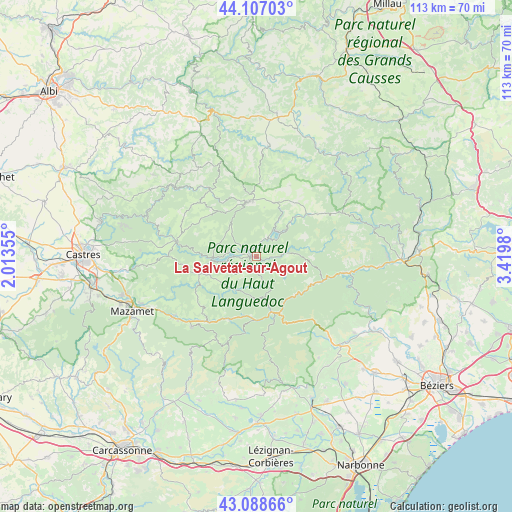
La Salvetat-sur-Agout GPS coordinates[2]
43° 36' 0" North, 2° 43' 0.012" East
| Map corner | latitude | longitude |
|---|---|---|
| Upper-left | 44.10703°, | 2.01355° |
| Center: | 43.6°, | 2.71667° |
| Lower-right: | 43.08866°, | 3.4198° |
| Map W x H: | 113.2×113.2 km | = 70.3×70.3mi |
| max Lat: | 51.07786° ⇑91.8% North |
| La Salvetat-sur-Agout: | 43.6° |
| min Lat: | ⇓8.2% South 41.3874° |
| min Long | La Salvetat-sur | max Long |
| -5.08615° | 2.71667° | 9.52242° |
| W 53.7%⇐ | ⇒46.3% E |
Elevation
Elevation of La Salvetat-sur-Agout is 784 m = 2572 ft, and this is 590.3 m = 1937 ft above average elevation for this country.
| Max E: |
2333 m = 7654 ft | 2.4% |
| La Salvetat-sur-Agout | 784 m 2572 ft | |
| Avg. | 193.7 m = 635 ft | |
Min E: |
-1 m = -3 ft | 97.6% |
See also: France elevation on elevation.city.
Geographical zone
La Salvetat-sur-Agout is located in North temperate zone (between Tropic of Cancer and the Arctic Circle). Distance of this Northern Tropic circle is 2241.9 km =1393.1 mi to South.| Distance of | km | miles | from La Salvetat-sur-Agout |
|---|---|---|---|
| North Pole | 5159.2 | 3205.8 | to North |
| Arctic Circle | 2553.3 | 1586.5 | to North |
| Tropic Cancer | 2241.9 | 1393.1 | to South |
| Equator | 4847.9 | 3012.3 | to South |


Nearby cities:
15 places around La Salvetat-sur-Agout: (largest is in red/bold)
• Albine
21.2 km =13.2 mi,  222°
222°
• Anglès
13.2 km =8.2 mi,  251°
251°
• Brassac
17.9 km =11.1 mi,  280°
280°
• Castelnau-de-Brassac
17 km =10.6 mi,  288°
288°
• Courniou
14 km =8.7 mi,  181°
181°
• Labastide-Rouairoux
15.2 km =9.4 mi,  204°
204°
• Lacaune
12 km =7.5 mi,  350°
350°
• Le Bez
19.4 km =12.1 mi,  271°
271°
• Mons
19.6 km =12.2 mi,  99°
99°
• Murat-sur-Vèbre
14.6 km =9.1 mi,  49°
49°
• Olargues
16.6 km =10.3 mi,  106°
106°
• Riols
12.3 km =7.6 mi,  149°
149°
• Saint-Amans-Valtoret
22.5 km =14 mi,  233°
233°
• Saint-Pons-de-Thomières
13.6 km =8.5 mi,  162°
162°
• Viane
18.5 km =11.5 mi,  324°
324°
Sources, notices
• [Note1] Compared only with cities in France existing in our database
• [Src1] Map data: © OpenStreetMap contributors (CC-BY-SA)
• [Src2] Other city data from geonames.org with taken over terms of usage.
• [Src3] Geographical zone / Annual Mean Temperature by Robert A. Rohde @ Wikipedia
