Saint-Hippolyte-du-Fort geodata
Saint-Hippolyte-du-Fort (Occitanie) is a populated place; located in France in Europe/Paris (GMT+2) time zone. With population of 3,717 people, there are 2641 cities with bigger population in this country. Compared to other cities in France, 87.4% of cities are located further ↑North; 66.6% of cities are located further ←West and 59.6% of cities have lower elevation than Saint-Hippolyte-du-Fort. Note1
Administrative division(s):
- Level 1: Occitanie
- Level 2: Gard
- Level 3: Arrondissement du Vigan
- Level 4: Saint-Hippolyte-du-Fort
Current local time in Saint-Hippolyte-du-Fort:
06:01 AM, WednesdayDifference from your time zone: hours


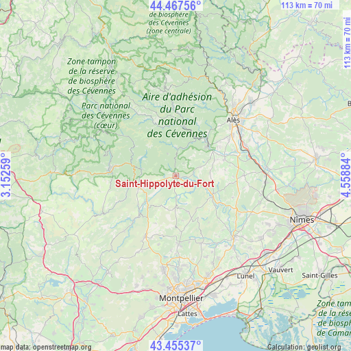
Saint-Hippolyte-du-Fort GPS coordinates[2]
43° 57' 49.032" North, 3° 51' 20.592" East
| Map corner | latitude | longitude |
|---|---|---|
| Upper-left | 44.46756°, | 3.15259° |
| Center: | 43.96362°, | 3.85572° |
| Lower-right: | 43.45537°, | 4.55884° |
| Map W x H: | 112.5×112.5 km | = 69.9×69.9mi |
| max Lat: | 51.07786° ⇑87.4% North |
| Saint-Hippolyte-du-Fort: | 43.96362° |
| min Lat: | ⇓12.6% South 41.3874° |
| min Long | Saint-Hippolyte | max Long |
| -5.08615° | 3.85572° | 9.52242° |
| W 66.6%⇐ | ⇒33.4% E |
Elevation
Elevation of Saint-Hippolyte-du-Fort is 168 m = 551 ft, and this is 25.7 m = 84 ft below average elevation for this country.
| Max E: |
2333 m = 7654 ft | 40.4% |
| Avg. | 193.7 m = 635 ft | |
| Saint-Hippolyte-du-Fort | 168 m = 551 ft | |
Min E: |
-1 m = -3 ft | 59.6% |
See also: France elevation on elevation.city.
Geographical zone
Saint-Hippolyte-du-Fort is located in North temperate zone (between Tropic of Cancer and the Arctic Circle). Distance of this Northern Tropic circle is 2282.4 km =1418.2 mi to South.| Distance of | km | miles | from Saint-Hippolyte-du-Fort |
|---|---|---|---|
| North Pole | 5118.8 | 3180.7 | to North |
| Arctic Circle | 2512.9 | 1561.4 | to North |
| Tropic Cancer | 2282.4 | 1418.2 | to South |
| Equator | 4888.3 | 3037.4 | to South |


Nearby cities:
15 places around Saint-Hippolyte-du-Fort: (largest is in red/bold)
• Anduze
14.5 km =9 mi,  45°
45°
• Cazilhac
13.2 km =8.2 mi,  248°
248°
• Claret
11.9 km =7.4 mi,  160°
160°
• Corconne
12.2 km =7.6 mi,  146°
146°
• Durfort-et-Saint-Martin-de-Sossenac
8.5 km =5.3 mi,  70°
70°
• Ganges
12.3 km =7.6 mi, 254°
• Laroque
11.5 km =7.1 mi, 246°
• Lasalle
9.1 km =5.7 mi,  359°
359°
• Monoblet
4.8 km =3 mi,  31°
31°
• Pompignan
7.8 km =4.8 mi,  179°
179°
• Quissac
12.8 km =8 mi,  115°
115°
• Saint-Bauzille-de-Putois
12.3 km =7.6 mi,  231°
231°
• Sauve
7.9 km =4.9 mi,  108°
108°
• Sumène
11.4 km =7.1 mi,  279°
279°
• Tornac
12.9 km =8 mi,  60°
60°
Sources, notices
• [Note1] Compared only with cities in France existing in our database
• [Src1] Map data: © OpenStreetMap contributors (CC-BY-SA)
• [Src2] Other city data from geonames.org with taken over terms of usage.
• [Src3] Geographical zone / Annual Mean Temperature by Robert A. Rohde @ Wikipedia
