Achiet-le-Grand geodata
Achiet-le-Grand (Hauts-de-France) is a populated place; located in France in Europe/Paris (GMT+2) time zone. With population of 1,031 people, there are 8609 cities with bigger population in this country. Compared to other cities in France, 94.4% of cities are located further ↓South; 54.6% of cities are located further ←West and 53.8% of cities have higher elevation than Achiet-le-Grand. Note1
Administrative division(s):
- Level 1: Hauts-de-France
- Level 2: Pas-de-Calais
- Level 3: Arras
- Level 4: Achiet-le-Grand


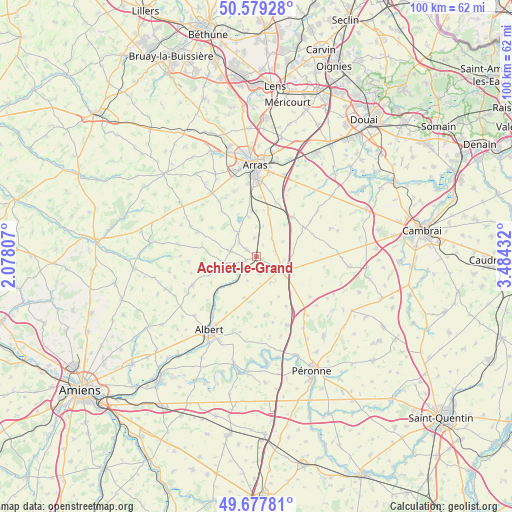
Achiet-le-Grand GPS coordinates[2]
50° 7' 50.412" North, 2° 46' 52.284" East
| Map corner | latitude | longitude |
|---|---|---|
| Upper-left | 50.57928°, | 2.07807° |
| Center: | 50.13067°, | 2.78119° |
| Lower-right: | 49.67781°, | 3.48432° |
| Map W x H: | 100.2×100.2 km | = 62.3×62.3mi |
| max Lat: | 51.07786° ⇑5.6% North |
| Achiet-le-Grand: | 50.13067° |
| min Lat: | ⇓94.4% South 41.3874° |
| min Long | Achiet-le-Grand | max Long |
| -5.08615° | 2.78119° | 9.52242° |
| W 54.6%⇐ | ⇒45.4% E |
Elevation
Elevation of Achiet-le-Grand is 120 m = 394 ft, and this is 73.7 m = 242 ft below average elevation for this country.
| Max E: |
2333 m = 7654 ft | 53.8% |
| Avg. | 193.7 m = 635 ft | |
| Achiet-le-Grand | 120 m = 394 ft | |
Min E: |
-1 m = -3 ft | 46.2% |
See also: France elevation on elevation.city.
Geographical zone
Achiet-le-Grand is located in North temperate zone (between Tropic of Cancer and the Arctic Circle). Distance of this North polar circle is 1827.2 km =1135.4 mi to North.| Distance of | km | miles | from Achiet-le-Grand |
|---|---|---|---|
| North Pole | 4433.1 | 2754.6 | to North |
| Arctic Circle | 1827.2 | 1135.4 | to North |
| Tropic Cancer | 2968.1 | 1844.3 | to South |
| Equator | 5574 | 3463.5 | to South |


Nearby cities:
15 places around Achiet-le-Grand: (largest is in red/bold)
• Agny
14.4 km =8.9 mi,  353°
353°
• Bapaume
5.7 km =3.5 mi,  121°
121°
• Beaumetz-lès-Cambrai
14.5 km =9 mi,  93°
93°
• Bucquoy
5.1 km =3.2 mi,  281°
281°
• Croisilles
10.4 km =6.5 mi,  42°
42°
• Ficheux
11.1 km =6.9 mi,  343°
343°
• Ligny-Thilloy
5.9 km =3.7 mi,  149°
149°
• Mailly-Maillet
13.8 km =8.6 mi,  245°
245°
• Mercatel
11.7 km =7.3 mi,  5°
5°
• Miraumont
5.4 km =3.4 mi,  222°
222°
• Neuville-Vitasse
13.3 km =8.3 mi, 12°
• Puisieux
6.4 km =4 mi,  255°
255°
• Rivière
13 km =8.1 mi,  330°
330°
• Vaulx-Vraucourt
9.3 km =5.8 mi,  77°
77°
• Wancourt
14.4 km =8.9 mi,  25°
25°
Sources, notices
• [Note1] Compared only with cities in France existing in our database
• [Src1] Map data: © OpenStreetMap contributors (CC-BY-SA)
• [Src2] Other city data from geonames.org with taken over terms of usage.
• [Src3] Geographical zone / Annual Mean Temperature by Robert A. Rohde @ Wikipedia
