Chef-Boutonne geodata
Chef-Boutonne (Nouvelle-Aquitaine) is a populated place; located in France in Europe/Paris (GMT+2) time zone. With population of 2,434 people, there are 3978 cities with bigger population in this country. Compared to other cities in France, 64.9% of cities are located further ↑North; 78.7% of cities are located further →East and 62.8% of cities have higher elevation than Chef-Boutonne. Note1
Administrative division(s):
- Level 1: Nouvelle-Aquitaine
- Level 2: Département des Deux-Sèvres
- Level 3: Arrondissement de Niort
- Level 4: Chef-Boutonne


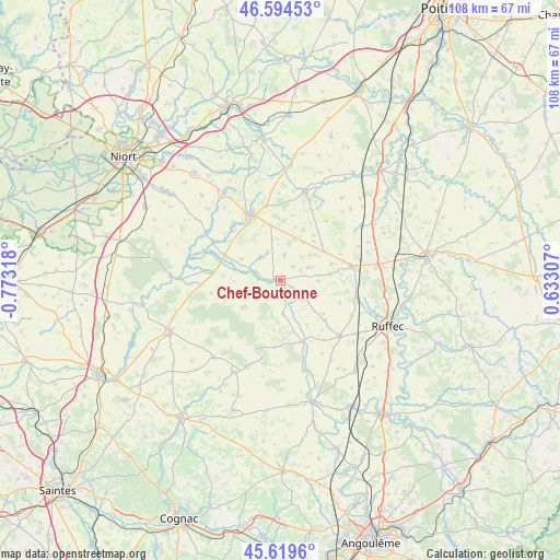
Chef-Boutonne GPS coordinates[2]
46° 6' 33.192" North, 0° 4' 12.18" West
| Map corner | latitude | longitude |
|---|---|---|
| Upper-left | 46.59453°, | -0.77318° |
| Center: | 46.10922°, | -0.07005° |
| Lower-right: | 45.6196°, | 0.63307° |
| Map W x H: | 108.4×108.4 km | = 67.4×67.4mi |
| max Lat: | 51.07786° ⇑64.9% North |
| Chef-Boutonne: | 46.10922° |
| min Lat: | ⇓35.1% South 41.3874° |
| min Long | Chef-Boutonne | max Long |
| -5.08615° | -0.07005° | 9.52242° |
| W 21.3%⇐ | ⇒78.7% E |
Elevation
Elevation of Chef-Boutonne is 95 m = 312 ft, and this is 98.7 m = 324 ft below average elevation for this country.
| Max E: |
2333 m = 7654 ft | 62.8% |
| Avg. | 193.7 m = 635 ft | |
| Chef-Boutonne | 95 m = 312 ft | |
Min E: |
-1 m = -3 ft | 37.2% |
See also: France elevation on elevation.city.
Geographical zone
Chef-Boutonne is located in North temperate zone (between Tropic of Cancer and the Arctic Circle). Distance of this North polar circle is 2274.3 km =1413.2 mi to North.| Distance of | km | miles | from Chef-Boutonne |
|---|---|---|---|
| North Pole | 4880.2 | 3032.4 | to North |
| Arctic Circle | 2274.3 | 1413.2 | to North |
| Tropic Cancer | 2520.9 | 1566.4 | to South |
| Equator | 5126.9 | 3185.7 | to South |


Nearby cities:
15 places around Chef-Boutonne: (largest is in red/bold)
• Brioux-sur-Boutonne
12.3 km =7.6 mi,  287°
287°
• Clussais
13.2 km =8.2 mi,  43°
43°
• Fontenille-Saint-Martin-d'Entraigues
4.9 km =3 mi,  279°
279°
• Gournay-Loizé
4.8 km =3 mi,  18°
18°
• La Faye
19.4 km =12.1 mi,  120°
120°
• Lezay
17.9 km =11.1 mi, 15°
• Limalonges
18.6 km =11.6 mi,  82°
82°
• Melle
14 km =8.7 mi,  336°
336°
• Melleran
6.1 km =3.8 mi,  65°
65°
• Périgné
16.7 km =10.4 mi,  301°
301°
• Saint-Martin-lès-Melle
14.4 km =8.9 mi,  329°
329°
• Saint-Romans-lès-Melle
14.2 km =8.8 mi,  319°
319°
• Saint-Vincent-la-Châtre
12.7 km =7.9 mi,  11°
11°
• Sauzé-Vaussais
13.9 km =8.6 mi, 78°
• Villefagnan
15.8 km =9.8 mi,  133°
133°
Sources, notices
• [Note1] Compared only with cities in France existing in our database
• [Src1] Map data: © OpenStreetMap contributors (CC-BY-SA)
• [Src2] Other city data from geonames.org with taken over terms of usage.
• [Src3] Geographical zone / Annual Mean Temperature by Robert A. Rohde @ Wikipedia
