Sauzé-Vaussais geodata
Sauzé-Vaussais (Nouvelle-Aquitaine) is a populated place; located in France in Europe/Paris (GMT+2) time zone. With population of 1,640 people, there are 5695 cities with bigger population in this country. Compared to other cities in France, 64.6% of cities are located further ↑North; 77.1% of cities are located further →East and 53.3% of cities have lower elevation than Sauzé-Vaussais. Note1
Administrative division(s):
- Level 1: Nouvelle-Aquitaine
- Level 2: Département des Deux-Sèvres
- Level 3: Arrondissement de Niort
- Level 4: Sauzé-Vaussais


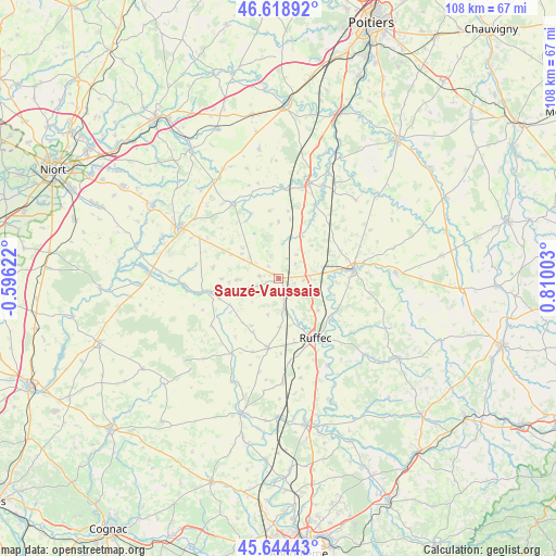
Sauzé-Vaussais GPS coordinates[2]
46° 8' 1.788" North, 0° 6' 24.876" East
| Map corner | latitude | longitude |
|---|---|---|
| Upper-left | 46.61892°, | -0.59622° |
| Center: | 46.13383°, | 0.10691° |
| Lower-right: | 45.64443°, | 0.81003° |
| Map W x H: | 108.4×108.4 km | = 67.4×67.4mi |
| max Lat: | 51.07786° ⇑64.6% North |
| Sauzé-Vaussais: | 46.13383° |
| min Lat: | ⇓35.4% South 41.3874° |
| min Long | Sauzé-Vaussais | max Long |
| -5.08615° | 0.10691° | 9.52242° |
| W 22.9%⇐ | ⇒77.1% E |
Elevation
Elevation of Sauzé-Vaussais is 144 m = 472 ft, and this is 49.7 m = 163 ft below average elevation for this country.
| Max E: |
2333 m = 7654 ft | 46.7% |
| Avg. | 193.7 m = 635 ft | |
| Sauzé-Vaussais | 144 m = 472 ft | |
Min E: |
-1 m = -3 ft | 53.3% |
See also: France elevation on elevation.city.
Geographical zone
Sauzé-Vaussais is located in North temperate zone (between Tropic of Cancer and the Arctic Circle). Distance of this North polar circle is 2271.6 km =1411.5 mi to North.| Distance of | km | miles | from Sauzé-Vaussais |
|---|---|---|---|
| North Pole | 4877.5 | 3030.7 | to North |
| Arctic Circle | 2271.6 | 1411.5 | to North |
| Tropic Cancer | 2523.7 | 1568.2 | to South |
| Equator | 5129.6 | 3187.4 | to South |


Nearby cities:
15 places around Sauzé-Vaussais: (largest is in red/bold)
• Blanzay
13.7 km =8.5 mi,  56°
56°
• Brux
13.1 km =8.1 mi,  30°
30°
• Chaunay
9.3 km =5.8 mi, 28°
• Chef-Boutonne
13.9 km =8.6 mi,  258°
258°
• Civray
14.6 km =9.1 mi,  83°
83°
• Clussais
8.3 km =5.2 mi,  326°
326°
• Gournay-Loizé
12.2 km =7.6 mi,  278°
278°
• La Faye
13 km =8.1 mi,  166°
166°
• Limalonges
4.8 km =3 mi,  94°
94°
• Melleran
8.1 km =5 mi,  268°
268°
• Ruffec
13.6 km =8.5 mi,  148°
148°
• Saint-Vincent-la-Châtre
14.8 km =9.2 mi,  311°
311°
• Savigné
16.7 km =10.4 mi, 80°
• Taizé-Aizie
12.5 km =7.8 mi,  127°
127°
• Villefagnan
13.8 km =8.6 mi,  188°
188°
Sources, notices
• [Note1] Compared only with cities in France existing in our database
• [Src1] Map data: © OpenStreetMap contributors (CC-BY-SA)
• [Src2] Other city data from geonames.org with taken over terms of usage.
• [Src3] Geographical zone / Annual Mean Temperature by Robert A. Rohde @ Wikipedia
