Gournay-Loizé geodata
Gournay-Loizé (Nouvelle-Aquitaine) is a populated place; located in France in Europe/Paris (GMT+2) time zone. With population of 597 people, there are 13370 cities with bigger population in this country. Compared to other cities in France, 64.3% of cities are located further ↑North; 78.5% of cities are located further →East and 54.5% of cities have lower elevation than Gournay-Loizé. Note1
Administrative division(s):
- Level 1: Nouvelle-Aquitaine
- Level 2: Département des Deux-Sèvres
- Level 3: Arrondissement de Niort
- Level 4: Alloinay


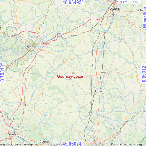
Gournay-Loizé GPS coordinates[2]
46° 9' 0" North, 0° 3' 0" West
| Map corner | latitude | longitude |
|---|---|---|
| Upper-left | 46.63495°, | -0.75313° |
| Center: | 46.15°, | -0.05° |
| Lower-right: | 45.66074°, | 0.65312° |
| Map W x H: | 108.3×108.3 km | = 67.3×67.3mi |
| max Lat: | 51.07786° ⇑64.3% North |
| Gournay-Loizé: | 46.15° |
| min Lat: | ⇓35.7% South 41.3874° |
| min Long | Gournay-Loizé | max Long |
| -5.08615° | -0.05° | 9.52242° |
| W 21.5%⇐ | ⇒78.5% E |
Elevation
Elevation of Gournay-Loizé is 148 m = 486 ft, and this is 45.7 m = 150 ft below average elevation for this country.
| Max E: |
2333 m = 7654 ft | 45.5% |
| Avg. | 193.7 m = 635 ft | |
| Gournay-Loizé | 148 m = 486 ft | |
Min E: |
-1 m = -3 ft | 54.5% |
See also: France elevation on elevation.city.
Geographical zone
Gournay-Loizé is located in North temperate zone (between Tropic of Cancer and the Arctic Circle). Distance of this North polar circle is 2269.8 km =1410.4 mi to North.| Distance of | km | miles | from Gournay-Loizé |
|---|---|---|---|
| North Pole | 4875.7 | 3029.6 | to North |
| Arctic Circle | 2269.8 | 1410.4 | to North |
| Tropic Cancer | 2525.5 | 1569.3 | to South |
| Equator | 5131.4 | 3188.5 | to South |


Nearby cities:
15 places around Gournay-Loizé: (largest is in red/bold)
• Brioux-sur-Boutonne
13.3 km =8.3 mi,  266°
266°
• Celles-sur-Belle
17.6 km =10.9 mi,  314°
314°
• Chef-Boutonne
4.8 km =3 mi,  198°
198°
• Chey
17.1 km =10.6 mi,  359°
359°
• Clussais
9.1 km =5.7 mi,  55°
55°
• Fontenille-Saint-Martin-d'Entraigues
7.4 km =4.6 mi,  240°
240°
• Lezay
13.2 km =8.2 mi,  13°
13°
• Limalonges
17 km =10.6 mi,  97°
97°
• Melle
10.9 km =6.8 mi,  318°
318°
• Melleran
4.5 km =2.8 mi,  117°
117°
• Périgné
16.3 km =10.1 mi,  284°
284°
• Saint-Martin-lès-Melle
11.9 km =7.4 mi, 311°
• Saint-Romans-lès-Melle
12.5 km =7.8 mi,  300°
300°
• Saint-Vincent-la-Châtre
8 km =5 mi, 7°
• Sauzé-Vaussais
12.2 km =7.6 mi, 98°
Sources, notices
• [Note1] Compared only with cities in France existing in our database
• [Src1] Map data: © OpenStreetMap contributors (CC-BY-SA)
• [Src2] Other city data from geonames.org with taken over terms of usage.
• [Src3] Geographical zone / Annual Mean Temperature by Robert A. Rohde @ Wikipedia
