Chavignon geodata
Chavignon (Hauts-de-France) is a populated place; located in France in Europe/Paris (GMT+2) time zone. With population of 798 people, there are 10635 cities with bigger population in this country. Compared to other cities in France, 89% of cities are located further ↓South; 64.5% of cities are located further ←West and 64.4% of cities have higher elevation than Chavignon. Note1
Administrative division(s):
- Level 1: Hauts-de-France
- Level 2: Département de l'Aisne
- Level 3: Arrondissement de Soissons
- Level 4: Chavignon


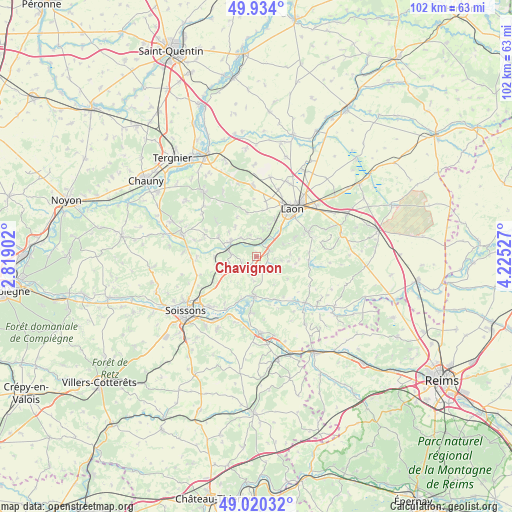
Chavignon GPS coordinates[2]
49° 28' 45.444" North, 3° 31' 19.704" East
| Map corner | latitude | longitude |
|---|---|---|
| Upper-left | 49.934°, | 2.81902° |
| Center: | 49.47929°, | 3.52214° |
| Lower-right: | 49.02032°, | 4.22527° |
| Map W x H: | 101.6×101.6 km | = 63.1×63.1mi |
| max Lat: | 51.07786° ⇑11% North |
| Chavignon: | 49.47929° |
| min Lat: | ⇓89% South 41.3874° |
| min Long | Chavignon | max Long |
| -5.08615° | 3.52214° | 9.52242° |
| W 64.5%⇐ | ⇒35.5% E |
Elevation
Elevation of Chavignon is 91 m = 299 ft, and this is 102.7 m = 337 ft below average elevation for this country.
| Max E: |
2333 m = 7654 ft | 64.4% |
| Avg. | 193.7 m = 635 ft | |
| Chavignon | 91 m = 299 ft | |
Min E: |
-1 m = -3 ft | 35.6% |
See also: France elevation on elevation.city.
Geographical zone
Chavignon is located in North temperate zone (between Tropic of Cancer and the Arctic Circle). Distance of this North polar circle is 1899.6 km =1180.4 mi to North.| Distance of | km | miles | from Chavignon |
|---|---|---|---|
| North Pole | 4505.5 | 2799.6 | to North |
| Arctic Circle | 1899.6 | 1180.4 | to North |
| Tropic Cancer | 2895.7 | 1799.3 | to South |
| Equator | 5501.6 | 3418.5 | to South |


Nearby cities:
15 places around Chavignon: (largest is in red/bold)
• Anizy-le-Château
6 km =3.7 mi,  300°
300°
• Bourg-et-Comin
13.2 km =8.2 mi,  133°
133°
• Brancourt-en-Laonnois
8.4 km =5.2 mi, 297°
• Bruyères-et-Montbérault
11.4 km =7.1 mi,  63°
63°
• Bucy-le-Long
13.4 km =8.3 mi,  222°
222°
• Chassemy
11 km =6.8 mi,  185°
185°
• Chivres-Val
11.2 km =7 mi,  213°
213°
• Chivy-lès-Étouvelles
6.8 km =4.2 mi,  36°
36°
• Crépy
13.4 km =8.3 mi,  358°
358°
• Laon
12 km =7.5 mi, 39°
• Missy-sur-Aisne
12 km =7.5 mi, 211°
• Pinon
5.5 km =3.4 mi,  281°
281°
• Prémontré
10.4 km =6.5 mi,  310°
310°
• Urcel
2.9 km =1.8 mi, 60°
• Vailly-sur-Aisne
7.9 km =4.9 mi,  183°
183°
Sources, notices
• [Note1] Compared only with cities in France existing in our database
• [Src1] Map data: © OpenStreetMap contributors (CC-BY-SA)
• [Src2] Other city data from geonames.org with taken over terms of usage.
• [Src3] Geographical zone / Annual Mean Temperature by Robert A. Rohde @ Wikipedia
