La Celle-Saint-Cloud geodata
La Celle-Saint-Cloud (Île-de-France) is a populated place; located in France in Europe/Paris (GMT+2) time zone. With population of 21,539 people, there are 417 cities with bigger population in this country. Compared to other cities in France, 76.6% of cities are located further ↓South; 55.2% of cities are located further →East and 57.1% of cities have lower elevation than La Celle-Saint-Cloud. Note1
Administrative division(s):
- Level 1: Île-de-France
- Level 2: Yvelines
- Level 3: Arrondissement de Versailles
- Level 4: La Celle-Saint-Cloud
Current local time in La Celle-Saint-Cloud:
01:13 AM, WednesdayDifference from your time zone: hours


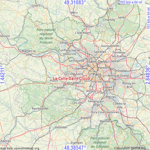
La Celle-Saint-Cloud GPS coordinates[2]
48° 51' 1.044" North, 2° 8' 42.828" East
| Map corner | latitude | longitude |
|---|---|---|
| Upper-left | 49.31083°, | 1.44211° |
| Center: | 48.85029°, | 2.14523° |
| Lower-right: | 48.38547°, | 2.84836° |
| Map W x H: | 102.9×102.9 km | = 63.9×63.9mi |
| max Lat: | 51.07786° ⇑23.4% North |
| La Celle-Saint-Cloud: | 48.85029° |
| min Lat: | ⇓76.6% South 41.3874° |
| min Long | La Celle-Saint- | max Long |
| -5.08615° | 2.14523° | 9.52242° |
| W 44.8%⇐ | ⇒55.2% E |
Elevation
Elevation of La Celle-Saint-Cloud is 158 m = 518 ft, and this is 35.7 m = 117 ft below average elevation for this country.
| Max E: |
2333 m = 7654 ft | 42.9% |
| Avg. | 193.7 m = 635 ft | |
| La Celle-Saint-Cloud | 158 m = 518 ft | |
Min E: |
-1 m = -3 ft | 57.1% |
See also: France elevation on elevation.city.
Geographical zone
La Celle-Saint-Cloud is located in North temperate zone (between Tropic of Cancer and the Arctic Circle). Distance of this North polar circle is 1969.5 km =1223.8 mi to North.| Distance of | km | miles | from La Celle-Saint-Cloud |
|---|---|---|---|
| North Pole | 4575.4 | 2843 | to North |
| Arctic Circle | 1969.5 | 1223.8 | to North |
| Tropic Cancer | 2825.7 | 1755.8 | to South |
| Equator | 5431.6 | 3375 | to South |


Nearby cities:
15 places around La Celle-Saint-Cloud: (largest is in red/bold)
• Bailly
5.1 km =3.2 mi,  259°
259°
• Bougival
1.4 km =0.9 mi,  348°
348°
• Chatou
4.5 km =2.8 mi,  12°
12°
• Croissy-sur-Seine
3.3 km =2.1 mi, 351°
• Garches
2.9 km =1.8 mi,  108°
108°
• Le Chesnay
3.6 km =2.2 mi,  208°
208°
• Le Vésinet
4.8 km =3 mi, 349°
• Louveciennes
2.5 km =1.6 mi,  298°
298°
• Marly-le-Roi
4.9 km =3 mi,  291°
291°
• Marnes-la-Coquette
3.2 km =2 mi,  143°
143°
• Rocquencourt
3.4 km =2.1 mi,  246°
246°
• Rueil-Malmaison
4.4 km =2.7 mi,  48°
48°
• Saint-Cloud
4.2 km =2.6 mi,  96°
96°
• Vaucresson
1.3 km =0.8 mi, 142°
• Ville-d’Avray
4.6 km =2.9 mi,  130°
130°
Sources, notices
• [Note1] Compared only with cities in France existing in our database
• [Src1] Map data: © OpenStreetMap contributors (CC-BY-SA)
• [Src2] Other city data from geonames.org with taken over terms of usage.
• [Src3] Geographical zone / Annual Mean Temperature by Robert A. Rohde @ Wikipedia
