Antran geodata
Antran (Nouvelle-Aquitaine) is a populated place; located in France in Europe/Paris (GMT+2) time zone. With population of 1,133 people, there are 7922 cities with bigger population in this country. Compared to other cities in France, 56.6% of cities are located further ↑North; 73% of cities are located further →East and 82.6% of cities have higher elevation than Antran. Note1
Administrative division(s):
- Level 1: Nouvelle-Aquitaine
- Level 2: Vienne
- Level 3: Arrondissement de Châtellerault
- Level 4: Antran


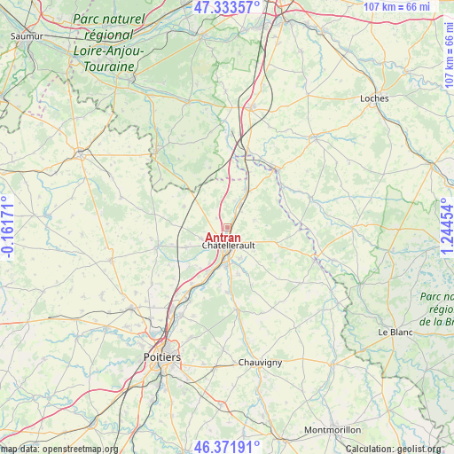
Antran GPS coordinates[2]
46° 51' 17.604" North, 0° 32' 29.076" East
| Map corner | latitude | longitude |
|---|---|---|
| Upper-left | 47.33357°, | -0.16171° |
| Center: | 46.85489°, | 0.54141° |
| Lower-right: | 46.37191°, | 1.24454° |
| Map W x H: | 106.9×106.9 km | = 66.4×66.4mi |
| max Lat: | 51.07786° ⇑56.6% North |
| Antran: | 46.85489° |
| min Lat: | ⇓43.4% South 41.3874° |
| min Long | Antran | max Long |
| -5.08615° | 0.54141° | 9.52242° |
| W 27%⇐ | ⇒73% E |
Elevation
Elevation of Antran is 48 m = 157 ft, and this is 145.7 m = 478 ft below average elevation for this country.
| Max E: |
2333 m = 7654 ft | 82.6% |
| Avg. | 193.7 m = 635 ft | |
| Antran | 48 m = 157 ft | |
Min E: |
-1 m = -3 ft | 17.4% |
See also: France elevation on elevation.city.
Geographical zone
Antran is located in North temperate zone (between Tropic of Cancer and the Arctic Circle). Distance of this North polar circle is 2191.4 km =1361.7 mi to North.| Distance of | km | miles | from Antran |
|---|---|---|---|
| North Pole | 4797.3 | 2980.9 | to North |
| Arctic Circle | 2191.4 | 1361.7 | to North |
| Tropic Cancer | 2603.9 | 1618 | to South |
| Equator | 5209.8 | 3237.2 | to South |


Nearby cities:
15 places around Antran: (largest is in red/bold)
• Cenon-sur-Vienne
9 km =5.6 mi,  182°
182°
• Châtellerault
4.2 km =2.6 mi, 176°
• Colombiers
12.8 km =8 mi,  223°
223°
• Dangé-Saint-Romain
9.8 km =6.1 mi,  27°
27°
• Les Ormes
13.9 km =8.6 mi,  20°
20°
• Marigny-Marmande
14.6 km =9.1 mi,  344°
344°
• Naintré
11.2 km =7 mi,  203°
203°
• Oyré
6.9 km =4.3 mi,  73°
73°
• Saint-Gervais-les-Trois-Clochers
11.4 km =7.1 mi,  296°
296°
• Saint-Sauveur
8.1 km =5 mi,  129°
129°
• Scorbé-Clairvaux
10.8 km =6.7 mi,  244°
244°
• Senillé
10.2 km =6.3 mi,  146°
146°
• Thuré
6.8 km =4.2 mi,  247°
247°
• Usseau
3.4 km =2.1 mi,  313°
313°
• Vaux-sur-Vienne
6.7 km =4.2 mi, 16°
Sources, notices
• [Note1] Compared only with cities in France existing in our database
• [Src1] Map data: © OpenStreetMap contributors (CC-BY-SA)
• [Src2] Other city data from geonames.org with taken over terms of usage.
• [Src3] Geographical zone / Annual Mean Temperature by Robert A. Rohde @ Wikipedia
