Embrun geodata
Embrun (Provence-Alpes-Côte d'Azur) is a populated place; located in France in Europe/Paris (GMT+2) time zone. With population of 7,069 people, there are 1378 cities with bigger population in this country. Compared to other cities in France, 83% of cities are located further ↑North; 91.7% of cities are located further ←West and 98.4% of cities have lower elevation than Embrun. Note1
Administrative division(s):
- Level 1: Provence-Alpes-Côte d'Azur
- Level 2: Hautes-Alpes
- Level 3: Arrondissement de Gap
- Level 4: Embrun


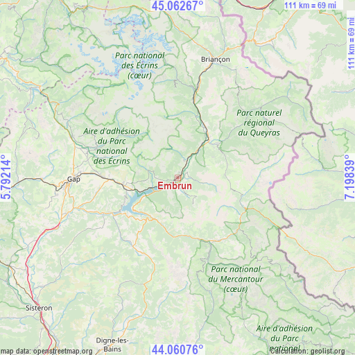
Embrun GPS coordinates[2]
44° 33' 49.932" North, 6° 29' 42.936" East
| Map corner | latitude | longitude |
|---|---|---|
| Upper-left | 45.06267°, | 5.79214° |
| Center: | 44.56387°, | 6.49526° |
| Lower-right: | 44.06076°, | 7.19839° |
| Map W x H: | 111.4×111.4 km | = 69.2×69.2mi |
| max Lat: | 51.07786° ⇑83% North |
| Embrun: | 44.56387° |
| min Lat: | ⇓17% South 41.3874° |
| min Long | Embrun | max Long |
| -5.08615° | 6.49526° | 9.52242° |
| W 91.7%⇐ | ⇒8.3% E |
Elevation
Elevation of Embrun is 869 m = 2851 ft, and this is 675.3 m = 2216 ft above average elevation for this country.
| Max E: |
2333 m = 7654 ft | 1.6% |
| Embrun | 869 m 2851 ft | |
| Avg. | 193.7 m = 635 ft | |
Min E: |
-1 m = -3 ft | 98.4% |
See also: France elevation on elevation.city.
Geographical zone
Embrun is located in North temperate zone (between Tropic of Cancer and the Arctic Circle). Distance of this Northern Tropic circle is 2349.1 km =1459.7 mi to South.| Distance of | km | miles | from Embrun |
|---|---|---|---|
| North Pole | 5052 | 3139.2 | to North |
| Arctic Circle | 2446.1 | 1519.9 | to North |
| Tropic Cancer | 2349.1 | 1459.7 | to South |
| Equator | 4955 | 3078.9 | to South |


Nearby cities:
15 places around Embrun: (largest is in red/bold)
• Ancelle
23.8 km =14.8 mi,  286°
286°
• Barcelonnette
23.3 km =14.5 mi,  147°
147°
• Chorges
17.4 km =10.8 mi,  264°
264°
• Châteauroux-les-Alpes
6 km =3.7 mi,  20°
20°
• Espinasses
23.6 km =14.7 mi,  242°
242°
• Guillestre
16.2 km =10.1 mi,  48°
48°
• Jausiers
24.7 km =15.3 mi,  131°
131°
• La Bâtie-Neuve
23.7 km =14.7 mi,  270°
270°
• La Roche-de-Rame
21.8 km =13.5 mi, 17°
• Orcières
19.1 km =11.9 mi,  314°
314°
• Risoul
14.7 km =9.1 mi, 50°
• Saint-Crépin
18.2 km =11.3 mi,  29°
29°
• Saint-Jean
25 km =15.5 mi,  298°
298°
• Savines-le-Lac
8.3 km =5.2 mi, 240°
• Vars
16 km =9.9 mi,  76°
76°
Sources, notices
• [Note1] Compared only with cities in France existing in our database
• [Src1] Map data: © OpenStreetMap contributors (CC-BY-SA)
• [Src2] Other city data from geonames.org with taken over terms of usage.
• [Src3] Geographical zone / Annual Mean Temperature by Robert A. Rohde @ Wikipedia
