Saint-Jean geodata
Saint-Jean (Provence-Alpes-Côte d'Azur) is a populated place; located in France in Europe/Paris (GMT+2) time zone. With population of 944 people, there are 9259 cities with bigger population in this country. Compared to other cities in France, 82.3% of cities are located further ↑North; 89.4% of cities are located further ←West and 99.5% of cities have lower elevation than Saint-Jean. Note1
Administrative division(s):
- Level 1: Provence-Alpes-Côte d'Azur
- Level 2: Hautes-Alpes
- Level 3: Arrondissement de Gap
- Level 4: Saint-Jean-Saint-Nicolas


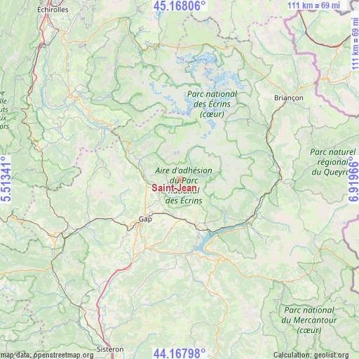
Saint-Jean GPS coordinates[2]
44° 40' 12.648" North, 6° 12' 59.544" East
| Map corner | latitude | longitude |
|---|---|---|
| Upper-left | 45.16806°, | 5.51341° |
| Center: | 44.67018°, | 6.21654° |
| Lower-right: | 44.16798°, | 6.91966° |
| Map W x H: | 111.2×111.2 km | = 69.1×69.1mi |
| max Lat: | 51.07786° ⇑82.3% North |
| Saint-Jean: | 44.67018° |
| min Lat: | ⇓17.7% South 41.3874° |
| min Long | Saint-Jean | max Long |
| -5.08615° | 6.21654° | 9.52242° |
| W 89.4%⇐ | ⇒10.6% E |
Elevation
Elevation of Saint-Jean is 1160 m = 3806 ft, and this is 966.3 m = 3170 ft above average elevation for this country.
| Max E: |
2333 m = 7654 ft | 0.5% |
| Saint-Jean | 1160 m 3806 ft | |
| Avg. | 193.7 m = 635 ft | |
Min E: |
-1 m = -3 ft | 99.5% |
See also: France elevation on elevation.city.
Geographical zone
Saint-Jean is located in North temperate zone (between Tropic of Cancer and the Arctic Circle). Distance of this Northern Tropic circle is 2360.9 km =1467 mi to South.| Distance of | km | miles | from Saint-Jean |
|---|---|---|---|
| North Pole | 5040.2 | 3131.8 | to North |
| Arctic Circle | 2434.3 | 1512.6 | to North |
| Tropic Cancer | 2360.9 | 1467 | to South |
| Equator | 4966.9 | 3086.3 | to South |


Nearby cities:
15 places around Saint-Jean: (largest is in red/bold)
• Ancelle
5.3 km =3.3 mi,  188°
188°
• Chabottes
3.6 km =2.2 mi,  241°
241°
• Chorges
14.3 km =8.9 mi,  160°
160°
• Châteauroux-les-Alpes
24.9 km =15.5 mi,  104°
104°
• Embrun
25 km =15.5 mi,  118°
118°
• Espinasses
22.7 km =14.1 mi,  177°
177°
• Gap
16.5 km =10.3 mi,  221°
221°
• La Bâtie-Neuve
11.6 km =7.2 mi, 188°
• La Roche-des-Arnauds
23.9 km =14.9 mi, 239°
• Le Dévoluy
22 km =13.7 mi,  276°
276°
• Neffes
24 km =14.9 mi, 219°
• Orcières
8.7 km =5.4 mi,  78°
78°
• Saint-Bonnet-en-Champsaur
10.6 km =6.6 mi, 277°
• Savines-le-Lac
21.8 km =13.5 mi,  137°
137°
• Tallard
26.6 km =16.5 mi,  209°
209°
Sources, notices
• [Note1] Compared only with cities in France existing in our database
• [Src1] Map data: © OpenStreetMap contributors (CC-BY-SA)
• [Src2] Other city data from geonames.org with taken over terms of usage.
• [Src3] Geographical zone / Annual Mean Temperature by Robert A. Rohde @ Wikipedia
