Belcodène geodata
Belcodène (Provence-Alpes-Côte d'Azur) is a populated place; located in France in Europe/Paris (GMT+2) time zone. With population of 1,533 people, there are 6071 cities with bigger population in this country. Compared to other cities in France, 94% of cities are located further ↑North; 83.6% of cities are located further ←West and 88.5% of cities have lower elevation than Belcodène. Note1
Administrative division(s):
- Level 1: Provence-Alpes-Côte d'Azur
- Level 2: Département des Bouches-du-Rhône
- Level 3: Arrondissement de Marseille
- Level 4: Belcodène


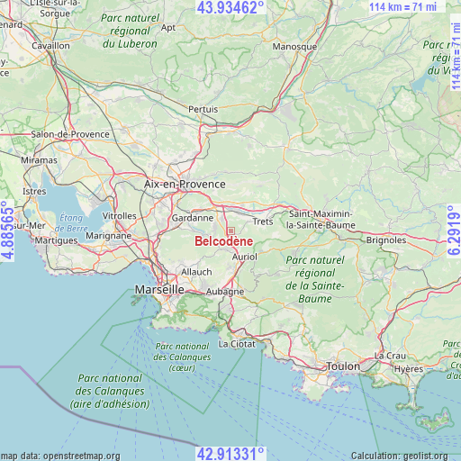
Belcodène GPS coordinates[2]
43° 25' 34.032" North, 5° 35' 19.608" East
| Map corner | latitude | longitude |
|---|---|---|
| Upper-left | 43.93462°, | 4.88565° |
| Center: | 43.42612°, | 5.58878° |
| Lower-right: | 42.91331°, | 6.2919° |
| Map W x H: | 113.6×113.6 km | = 70.6×70.6mi |
| max Lat: | 51.07786° ⇑94% North |
| Belcodène: | 43.42612° |
| min Lat: | ⇓6% South 41.3874° |
| min Long | Belcodène | max Long |
| -5.08615° | 5.58878° | 9.52242° |
| W 83.6%⇐ | ⇒16.4% E |
Elevation
Elevation of Belcodène is 396 m = 1299 ft, and this is 202.3 m = 664 ft above average elevation for this country.
| Max E: |
2333 m = 7654 ft | 11.5% |
| Belcodène | 396 m 1299 ft | |
| Avg. | 193.7 m = 635 ft | |
Min E: |
-1 m = -3 ft | 88.5% |
See also: France elevation on elevation.city.
Geographical zone
Belcodène is located in North temperate zone (between Tropic of Cancer and the Arctic Circle). Distance of this Northern Tropic circle is 2222.6 km =1381.1 mi to South.| Distance of | km | miles | from Belcodène |
|---|---|---|---|
| North Pole | 5178.5 | 3217.8 | to North |
| Arctic Circle | 2572.6 | 1598.5 | to North |
| Tropic Cancer | 2222.6 | 1381.1 | to South |
| Equator | 4828.5 | 3000.3 | to South |


Nearby cities:
15 places around Belcodène: (largest is in red/bold)
• Auriol
7.1 km =4.4 mi,  148°
148°
• Cadolive
4.8 km =3 mi,  227°
227°
• Châteauneuf-le-Rouge
7.2 km =4.5 mi,  347°
347°
• Fuveau
4 km =2.5 mi,  326°
326°
• Gardanne
10.2 km =6.3 mi,  288°
288°
• Gréasque
3.7 km =2.3 mi,  282°
282°
• La Bouilladisse
3.3 km =2.1 mi,  174°
174°
• La Destrousse
5.8 km =3.6 mi, 166°
• Mimet
6.8 km =4.2 mi,  258°
258°
• Peynier
4.9 km =3 mi,  59°
59°
• Peypin
4.7 km =2.9 mi,  190°
190°
• Roquevaire
8.5 km =5.3 mi, 171°
• Rousset
6.8 km =4.2 mi,  21°
21°
• Saint-Savournin
5.4 km =3.4 mi,  248°
248°
• Trets
8 km =5 mi,  72°
72°
Sources, notices
• [Note1] Compared only with cities in France existing in our database
• [Src1] Map data: © OpenStreetMap contributors (CC-BY-SA)
• [Src2] Other city data from geonames.org with taken over terms of usage.
• [Src3] Geographical zone / Annual Mean Temperature by Robert A. Rohde @ Wikipedia
