Peynier geodata
Peynier (Provence-Alpes-Côte d'Azur) is a populated place; located in France in Europe/Paris (GMT+2) time zone. With population of 3,059 people, there are 3181 cities with bigger population in this country. Compared to other cities in France, 93.7% of cities are located further ↑North; 84% of cities are located further ←West and 78% of cities have lower elevation than Peynier. Note1
Administrative division(s):
- Level 1: Provence-Alpes-Côte d'Azur
- Level 2: Département des Bouches-du-Rhône
- Level 3: Aix-en-Provence
- Level 4: Peynier


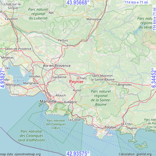
Peynier GPS coordinates[2]
43° 26' 54.132" North, 5° 38' 29.004" East
| Map corner | latitude | longitude |
|---|---|---|
| Upper-left | 43.95668°, | 4.93827° |
| Center: | 43.44837°, | 5.64139° |
| Lower-right: | 42.93575°, | 6.34452° |
| Map W x H: | 113.5×113.5 km | = 70.5×70.5mi |
| max Lat: | 51.07786° ⇑93.7% North |
| Peynier: | 43.44837° |
| min Lat: | ⇓6.3% South 41.3874° |
| min Long | Peynier | max Long |
| -5.08615° | 5.64139° | 9.52242° |
| W 84%⇐ | ⇒16% E |
Elevation
Elevation of Peynier is 272 m = 892 ft, and this is 78.3 m = 257 ft above average elevation for this country.
| Max E: |
2333 m = 7654 ft | 22% |
| Peynier | 272 m 892 ft | |
| Avg. | 193.7 m = 635 ft | |
Min E: |
-1 m = -3 ft | 78% |
See also: France elevation on elevation.city.
Geographical zone
Peynier is located in North temperate zone (between Tropic of Cancer and the Arctic Circle). Distance of this Northern Tropic circle is 2225.1 km =1382.6 mi to South.| Distance of | km | miles | from Peynier |
|---|---|---|---|
| North Pole | 5176.1 | 3216.3 | to North |
| Arctic Circle | 2570.2 | 1597 | to North |
| Tropic Cancer | 2225.1 | 1382.6 | to South |
| Equator | 4831 | 3001.8 | to South |


Nearby cities:
15 places around Peynier: (largest is in red/bold)
• Auriol
8.6 km =5.3 mi,  183°
183°
• Belcodène
4.9 km =3 mi,  239°
239°
• Cadolive
9.6 km =6 mi,  233°
233°
• Châteauneuf-le-Rouge
7.4 km =4.6 mi,  308°
308°
• Fuveau
6.5 km =4 mi,  277°
277°
• Gréasque
8 km =5 mi,  257°
257°
• La Bouilladisse
7 km =4.3 mi,  213°
213°
• La Destrousse
8.6 km =5.3 mi,  199°
199°
• Peypin
8.7 km =5.4 mi,  216°
216°
• Pourrières
9.9 km =6.2 mi,  49°
49°
• Puyloubier
9 km =5.6 mi,  18°
18°
• Rousset
4.2 km =2.6 mi,  335°
335°
• Saint-Savournin
10.3 km =6.4 mi, 244°
• Saint-Zacharie
8.9 km =5.5 mi,  142°
142°
• Trets
3.4 km =2.1 mi,  90°
90°
Sources, notices
• [Note1] Compared only with cities in France existing in our database
• [Src1] Map data: © OpenStreetMap contributors (CC-BY-SA)
• [Src2] Other city data from geonames.org with taken over terms of usage.
• [Src3] Geographical zone / Annual Mean Temperature by Robert A. Rohde @ Wikipedia
