Châteaumeillant geodata
Châteaumeillant (Centre) is a populated place; located in France in Europe/Paris (GMT+2) time zone. With population of 2,089 people, there are 4611 cities with bigger population in this country. Compared to other cities in France, 59.6% of cities are located further ↑North; 54.5% of cities are located further →East and 73.8% of cities have lower elevation than Châteaumeillant. Note1
Administrative division(s):
- Level 1: Centre
- Level 2: Cher
- Level 3: Arrondissement de Saint-Amand-Montrond
- Level 4: Châteaumeillant


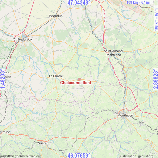
Châteaumeillant GPS coordinates[2]
46° 33' 43.884" North, 2° 11' 42.54" East
| Map corner | latitude | longitude |
|---|---|---|
| Upper-left | 47.04348°, | 1.49203° |
| Center: | 46.56219°, | 2.19515° |
| Lower-right: | 46.07659°, | 2.89828° |
| Map W x H: | 107.5×107.5 km | = 66.8×66.8mi |
| max Lat: | 51.07786° ⇑59.6% North |
| Châteaumeillant: | 46.56219° |
| min Lat: | ⇓40.4% South 41.3874° |
| min Long | Châteaumeillan | max Long |
| -5.08615° | 2.19515° | 9.52242° |
| W 45.5%⇐ | ⇒54.5% E |
Elevation
Elevation of Châteaumeillant is 241 m = 791 ft, and this is 47.3 m = 155 ft above average elevation for this country.
| Max E: |
2333 m = 7654 ft | 26.2% |
| Châteaumeillant | 241 m 791 ft | |
| Avg. | 193.7 m = 635 ft | |
Min E: |
-1 m = -3 ft | 73.8% |
See also: France elevation on elevation.city.
Geographical zone
Châteaumeillant is located in North temperate zone (between Tropic of Cancer and the Arctic Circle). Distance of this North polar circle is 2223.9 km =1381.9 mi to North.| Distance of | km | miles | from Châteaumeillant |
|---|---|---|---|
| North Pole | 4829.8 | 3001.1 | to North |
| Arctic Circle | 2223.9 | 1381.9 | to North |
| Tropic Cancer | 2571.3 | 1597.7 | to South |
| Equator | 5177.2 | 3217 | to South |


Nearby cities:
15 places around Châteaumeillant: (largest is in red/bold)
• Briantes
13.3 km =8.3 mi,  267°
267°
• Chassignolles
19.7 km =12.2 mi,  263°
263°
• Culan
11.9 km =7.4 mi,  97°
97°
• La Châtre
16 km =9.9 mi,  278°
278°
• Lacs
13.3 km =8.3 mi, 281°
• Le Châtelet
11.1 km =6.9 mi,  36°
36°
• Le Magny
18.3 km =11.4 mi, 272°
• Lignières
21.1 km =13.1 mi,  355°
355°
• Montgivray
16.9 km =10.5 mi,  285°
285°
• Pouligny-Notre-Dame
16.2 km =10.1 mi,  237°
237°
• Préveranges
15.1 km =9.4 mi,  162°
162°
• Saint-Chartier
19.2 km =11.9 mi,  300°
300°
• Saint-Hilaire-en-Lignières
18.3 km =11.4 mi,  354°
354°
• Sainte-Sévère-sur-Indre
12.7 km =7.9 mi,  228°
228°
• Vesdun
18 km =11.2 mi, 98°
Sources, notices
• [Note1] Compared only with cities in France existing in our database
• [Src1] Map data: © OpenStreetMap contributors (CC-BY-SA)
• [Src2] Other city data from geonames.org with taken over terms of usage.
• [Src3] Geographical zone / Annual Mean Temperature by Robert A. Rohde @ Wikipedia
