Lignières geodata
Lignières (Centre) is a populated place; located in France in Europe/Paris (GMT+2) time zone. With population of 1,637 people, there are 5706 cities with bigger population in this country. Compared to other cities in France, 57.7% of cities are located further ↑North; 54.8% of cities are located further →East and 58% of cities have lower elevation than Lignières. Note1
Administrative division(s):
- Level 1: Centre
- Level 2: Cher
- Level 3: Arrondissement de Saint-Amand-Montrond
- Level 4: Lignières


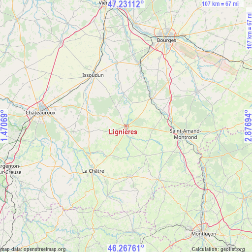
Lignières GPS coordinates[2]
46° 45' 5.472" North, 2° 10' 25.716" East
| Map corner | latitude | longitude |
|---|---|---|
| Upper-left | 47.23112°, | 1.47069° |
| Center: | 46.75152°, | 2.17381° |
| Lower-right: | 46.26761°, | 2.87694° |
| Map W x H: | 107.1×107.1 km | = 66.5×66.5mi |
| max Lat: | 51.07786° ⇑57.7% North |
| Lignières: | 46.75152° |
| min Lat: | ⇓42.3% South 41.3874° |
| min Long | Lignières | max Long |
| -5.08615° | 2.17381° | 9.52242° |
| W 45.2%⇐ | ⇒54.8% E |
Elevation
Elevation of Lignières is 161 m = 528 ft, and this is 32.7 m = 107 ft below average elevation for this country.
| Max E: |
2333 m = 7654 ft | 42% |
| Avg. | 193.7 m = 635 ft | |
| Lignières | 161 m = 528 ft | |
Min E: |
-1 m = -3 ft | 58% |
See also: France elevation on elevation.city.
Geographical zone
Lignières is located in North temperate zone (between Tropic of Cancer and the Arctic Circle). Distance of this North polar circle is 2202.9 km =1368.8 mi to North.| Distance of | km | miles | from Lignières |
|---|---|---|---|
| North Pole | 4808.8 | 2988 | to North |
| Arctic Circle | 2202.9 | 1368.8 | to North |
| Tropic Cancer | 2592.4 | 1610.8 | to South |
| Equator | 5198.3 | 3230.1 | to South |


Nearby cities:
15 places around Lignières: (largest is in red/bold)
• Ambrault
16.7 km =10.4 mi,  282°
282°
• Bruère-Allichamps
19.8 km =12.3 mi,  84°
84°
• Chezal-Benoît
9.3 km =5.8 mi,  330°
330°
• Châteaumeillant
21.1 km =13.1 mi,  175°
175°
• Châteauneuf-sur-Cher
16.1 km =10 mi,  42°
42°
• Lacs
21.6 km =13.4 mi,  211°
211°
• Le Châtelet
14.7 km =9.1 mi,  145°
145°
• Lunery
21.7 km =13.5 mi,  19°
19°
• Mareuil-sur-Arnon
14.4 km =8.9 mi,  355°
355°
• Pruniers
10.3 km =6.4 mi,  294°
294°
• Saint-Août
16 km =9.9 mi,  261°
261°
• Saint-Chartier
18.8 km =11.7 mi,  232°
232°
• Saint-Hilaire-en-Lignières
2.8 km =1.7 mi, 181°
• Vallenay
15.5 km =9.6 mi, 76°
• Venesmes
14.3 km =8.9 mi,  47°
47°
Sources, notices
• [Note1] Compared only with cities in France existing in our database
• [Src1] Map data: © OpenStreetMap contributors (CC-BY-SA)
• [Src2] Other city data from geonames.org with taken over terms of usage.
• [Src3] Geographical zone / Annual Mean Temperature by Robert A. Rohde @ Wikipedia
