Chanteix geodata
Chanteix (Nouvelle-Aquitaine) is a populated place; located in France in Europe/Paris (GMT+2) time zone. With population of 523 people, there are 14759 cities with bigger population in this country. Compared to other cities in France, 76.2% of cities are located further ↑North; 61.1% of cities are located further →East and 87.9% of cities have lower elevation than Chanteix. Note1
Administrative division(s):
- Level 1: Nouvelle-Aquitaine
- Level 2: Département de la Corrèze
- Level 3: Arrondissement de Tulle
- Level 4: Chanteix


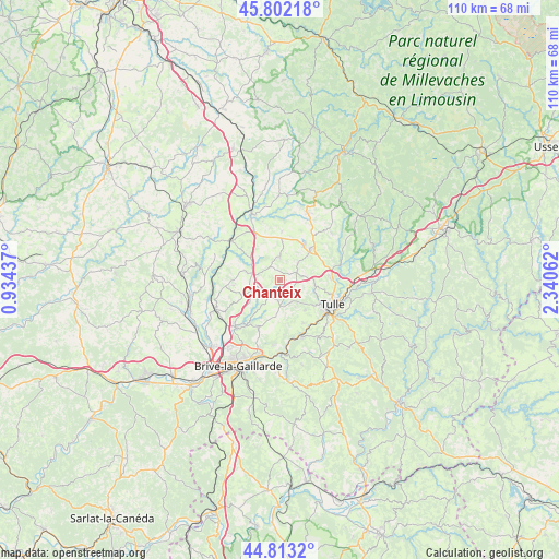
Chanteix GPS coordinates[2]
45° 18' 35.46" North, 1° 38' 14.964" East
| Map corner | latitude | longitude |
|---|---|---|
| Upper-left | 45.80218°, | 0.93437° |
| Center: | 45.30985°, | 1.63749° |
| Lower-right: | 44.8132°, | 2.34062° |
| Map W x H: | 110×110 km | = 68.4×68.4mi |
| max Lat: | 51.07786° ⇑76.2% North |
| Chanteix: | 45.30985° |
| min Lat: | ⇓23.8% South 41.3874° |
| min Long | Chanteix | max Long |
| -5.08615° | 1.63749° | 9.52242° |
| W 38.9%⇐ | ⇒61.1% E |
Elevation
Elevation of Chanteix is 387 m = 1270 ft, and this is 193.3 m = 634 ft above average elevation for this country.
| Max E: |
2333 m = 7654 ft | 12.1% |
| Chanteix | 387 m 1270 ft | |
| Avg. | 193.7 m = 635 ft | |
Min E: |
-1 m = -3 ft | 87.9% |
See also: France elevation on elevation.city.
Geographical zone
Chanteix is located in North temperate zone (between Tropic of Cancer and the Arctic Circle). Distance of this North polar circle is 2363.2 km =1468.4 mi to North.| Distance of | km | miles | from Chanteix |
|---|---|---|---|
| North Pole | 4969.1 | 3087.7 | to North |
| Arctic Circle | 2363.2 | 1468.4 | to North |
| Tropic Cancer | 2432.1 | 1511.2 | to South |
| Equator | 5038 | 3130.5 | to South |


Nearby cities:
15 places around Chanteix: (largest is in red/bold)
• Chameyrat
9.7 km =6 mi,  150°
150°
• Cornil
11.8 km =7.3 mi,  158°
158°
• Lagraulière
4.8 km =3 mi,  1°
1°
• Naves
10.1 km =6.3 mi,  87°
87°
• Perpezac-le-Noir
6.9 km =4.3 mi,  285°
285°
• Sadroc
7.5 km =4.7 mi,  246°
246°
• Saint-Clément
5.1 km =3.2 mi,  46°
46°
• Saint-Germain-les-Vergnes
4 km =2.5 mi,  182°
182°
• Saint-Hilaire-Peyroux
10.7 km =6.6 mi, 175°
• Saint-Jal
9.7 km =6 mi, 2°
• Saint-Mexant
3.2 km =2 mi, 149°
• Sainte-Féréole
9.9 km =6.2 mi,  205°
205°
• Seilhac
8.7 km =5.4 mi,  43°
43°
• Tulle
11.6 km =7.2 mi,  114°
114°
• Vigeois
12.2 km =7.6 mi,  309°
309°
Sources, notices
• [Note1] Compared only with cities in France existing in our database
• [Src1] Map data: © OpenStreetMap contributors (CC-BY-SA)
• [Src2] Other city data from geonames.org with taken over terms of usage.
• [Src3] Geographical zone / Annual Mean Temperature by Robert A. Rohde @ Wikipedia
