Lagraulière geodata
Lagraulière (Nouvelle-Aquitaine) is a populated place; located in France in Europe/Paris (GMT+2) time zone. With population of 942 people, there are 9275 cities with bigger population in this country. Compared to other cities in France, 75.8% of cities are located further ↑North; 61.1% of cities are located further →East and 89.6% of cities have lower elevation than Lagraulière. Note1
Administrative division(s):
- Level 1: Nouvelle-Aquitaine
- Level 2: Département de la Corrèze
- Level 3: Arrondissement de Tulle
- Level 4: Lagraulière


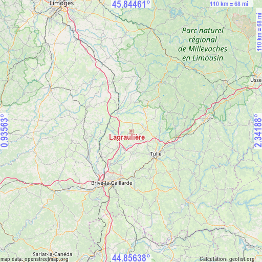
Lagraulière GPS coordinates[2]
45° 21' 9.54" North, 1° 38' 19.5" East
| Map corner | latitude | longitude |
|---|---|---|
| Upper-left | 45.84461°, | 0.93563° |
| Center: | 45.35265°, | 1.63875° |
| Lower-right: | 44.85638°, | 2.34188° |
| Map W x H: | 109.9×109.9 km | = 68.3×68.3mi |
| max Lat: | 51.07786° ⇑75.8% North |
| Lagraulière: | 45.35265° |
| min Lat: | ⇓24.2% South 41.3874° |
| min Long | Lagraulière | max Long |
| -5.08615° | 1.63875° | 9.52242° |
| W 38.9%⇐ | ⇒61.1% E |
Elevation
Elevation of Lagraulière is 417 m = 1368 ft, and this is 223.3 m = 733 ft above average elevation for this country.
| Max E: |
2333 m = 7654 ft | 10.4% |
| Lagraulière | 417 m 1368 ft | |
| Avg. | 193.7 m = 635 ft | |
Min E: |
-1 m = -3 ft | 89.6% |
See also: France elevation on elevation.city.
Geographical zone
Lagraulière is located in North temperate zone (between Tropic of Cancer and the Arctic Circle). Distance of this North polar circle is 2358.4 km =1465.4 mi to North.| Distance of | km | miles | from Lagraulière |
|---|---|---|---|
| North Pole | 4964.3 | 3084.7 | to North |
| Arctic Circle | 2358.4 | 1465.4 | to North |
| Tropic Cancer | 2436.8 | 1514.2 | to South |
| Equator | 5042.7 | 3133.4 | to South |


Nearby cities:
15 places around Lagraulière: (largest is in red/bold)
• Chamboulive
10.2 km =6.3 mi,  30°
30°
• Chameyrat
14 km =8.7 mi,  160°
160°
• Chanteix
4.8 km =3 mi,  181°
181°
• Condat-sur-Ganaveix
13.2 km =8.2 mi,  344°
344°
• Eyburie
11.9 km =7.4 mi,  358°
358°
• Naves
10.9 km =6.8 mi,  113°
113°
• Perpezac-le-Noir
7.4 km =4.6 mi,  246°
246°
• Sadroc
10.5 km =6.5 mi,  222°
222°
• Saint-Clément
3.8 km =2.4 mi, 108°
• Saint-Germain-les-Vergnes
8.8 km =5.5 mi, 181°
• Saint-Jal
4.9 km =3 mi,  4°
4°
• Saint-Mexant
7.7 km =4.8 mi,  168°
168°
• Seilhac
6.1 km =3.8 mi,  74°
74°
• Uzerche
9.9 km =6.2 mi,  323°
323°
• Vigeois
9.9 km =6.2 mi,  287°
287°
Sources, notices
• [Note1] Compared only with cities in France existing in our database
• [Src1] Map data: © OpenStreetMap contributors (CC-BY-SA)
• [Src2] Other city data from geonames.org with taken over terms of usage.
• [Src3] Geographical zone / Annual Mean Temperature by Robert A. Rohde @ Wikipedia
