Naves geodata
Naves (Nouvelle-Aquitaine) is a populated place; located in France in Europe/Paris (GMT+2) time zone. With population of 2,441 people, there are 3967 cities with bigger population in this country. Compared to other cities in France, 76.2% of cities are located further ↑North; 59.8% of cities are located further →East and 89.3% of cities have lower elevation than Naves. Note1
Administrative division(s):
- Level 1: Nouvelle-Aquitaine
- Level 2: Département de la Corrèze
- Level 3: Arrondissement de Tulle
- Level 4: Naves


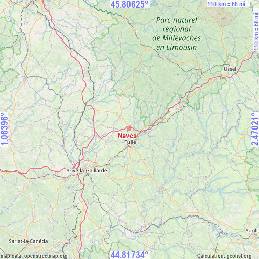
Naves GPS coordinates[2]
45° 18' 50.22" North, 1° 46' 1.488" East
| Map corner | latitude | longitude |
|---|---|---|
| Upper-left | 45.80625°, | 1.06396° |
| Center: | 45.31395°, | 1.76708° |
| Lower-right: | 44.81734°, | 2.47021° |
| Map W x H: | 110×110 km | = 68.4×68.4mi |
| max Lat: | 51.07786° ⇑76.2% North |
| Naves: | 45.31395° |
| min Lat: | ⇓23.8% South 41.3874° |
| min Long | Naves | max Long |
| -5.08615° | 1.76708° | 9.52242° |
| W 40.2%⇐ | ⇒59.8% E |
Elevation
Elevation of Naves is 412 m = 1352 ft, and this is 218.3 m = 716 ft above average elevation for this country.
| Max E: |
2333 m = 7654 ft | 10.7% |
| Naves | 412 m 1352 ft | |
| Avg. | 193.7 m = 635 ft | |
Min E: |
-1 m = -3 ft | 89.3% |
See also: France elevation on elevation.city.
Geographical zone
Naves is located in North temperate zone (between Tropic of Cancer and the Arctic Circle). Distance of this North polar circle is 2362.7 km =1468.1 mi to North.| Distance of | km | miles | from Naves |
|---|---|---|---|
| North Pole | 4968.6 | 3087.3 | to North |
| Arctic Circle | 2362.7 | 1468.1 | to North |
| Tropic Cancer | 2432.5 | 1511.5 | to South |
| Equator | 5038.4 | 3130.7 | to South |


Nearby cities:
15 places around Naves: (largest is in red/bold)
• Chameyrat
10.4 km =6.5 mi,  211°
211°
• Chanac-les-Mines
6.9 km =4.3 mi,  143°
143°
• Chanteix
10.1 km =6.3 mi,  267°
267°
• Cornil
12.9 km =8 mi, 207°
• Corrèze
10.7 km =6.6 mi,  52°
52°
• Gimel-les-Cascades
6.7 km =4.2 mi,  103°
103°
• Lagraulière
10.9 km =6.8 mi,  293°
293°
• Laguenne
8.1 km =5 mi,  172°
172°
• Saint-Clément
7.1 km =4.4 mi,  295°
295°
• Saint-Germain-les-Vergnes
11.3 km =7 mi,  246°
246°
• Saint-Jal
13.3 km =8.3 mi,  313°
313°
• Saint-Mexant
9.1 km =5.7 mi, 249°
• Sainte-Fortunade
11.9 km =7.4 mi,  178°
178°
• Seilhac
7.2 km =4.5 mi,  324°
324°
• Tulle
5.4 km =3.4 mi, 175°
Sources, notices
• [Note1] Compared only with cities in France existing in our database
• [Src1] Map data: © OpenStreetMap contributors (CC-BY-SA)
• [Src2] Other city data from geonames.org with taken over terms of usage.
• [Src3] Geographical zone / Annual Mean Temperature by Robert A. Rohde @ Wikipedia
