La Canourgue geodata
La Canourgue (Occitanie) is a populated place; located in France in Europe/Paris (GMT+2) time zone. With population of 2,126 people, there are 4527 cities with bigger population in this country. Compared to other cities in France, 84% of cities are located further ↑North; 60.8% of cities are located further ←West and 94.6% of cities have lower elevation than La Canourgue. Note1
Administrative division(s):
- Level 1: Occitanie
- Level 2: Département de la Lozère
- Level 3: Arrondissement de Mende
- Level 4: La Canourgue


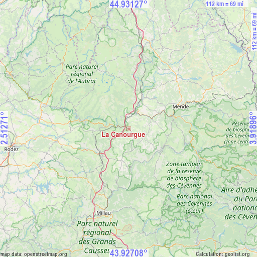
La Canourgue GPS coordinates[2]
44° 25' 52.788" North, 3° 12' 57.024" East
| Map corner | latitude | longitude |
|---|---|---|
| Upper-left | 44.93127°, | 2.51271° |
| Center: | 44.43133°, | 3.21584° |
| Lower-right: | 43.92708°, | 3.91896° |
| Map W x H: | 111.7×111.7 km | = 69.4×69.4mi |
| max Lat: | 51.07786° ⇑84% North |
| La Canourgue: | 44.43133° |
| min Lat: | ⇓16% South 41.3874° |
| min Long | La Canourgue | max Long |
| -5.08615° | 3.21584° | 9.52242° |
| W 60.8%⇐ | ⇒39.2% E |
Elevation
Elevation of La Canourgue is 565 m = 1854 ft, and this is 371.3 m = 1218 ft above average elevation for this country.
| Max E: |
2333 m = 7654 ft | 5.4% |
| La Canourgue | 565 m 1854 ft | |
| Avg. | 193.7 m = 635 ft | |
Min E: |
-1 m = -3 ft | 94.6% |
See also: France elevation on elevation.city.
Geographical zone
La Canourgue is located in North temperate zone (between Tropic of Cancer and the Arctic Circle). Distance of this Northern Tropic circle is 2334.4 km =1450.5 mi to South.| Distance of | km | miles | from La Canourgue |
|---|---|---|---|
| North Pole | 5066.8 | 3148.4 | to North |
| Arctic Circle | 2460.9 | 1529.1 | to North |
| Tropic Cancer | 2334.4 | 1450.5 | to South |
| Equator | 4940.3 | 3069.8 | to South |


Nearby cities:
15 places around La Canourgue: (largest is in red/bold)
• Balsièges
19.9 km =12.4 mi,  74°
74°
• Banassac
1.4 km =0.9 mi,  293°
293°
• Barjac
17.4 km =10.8 mi,  62°
62°
• Chanac
10.8 km =6.7 mi, 69°
• Chirac
10.9 km =6.8 mi,  21°
21°
• Ispagnac
26.5 km =16.5 mi,  104°
104°
• Lapanouse
18.1 km =11.2 mi,  234°
234°
• Le Monastier-Pin-Moriès
9.9 km =6.2 mi, 15°
• Marvejols
14.9 km =9.3 mi, 23°
• Mende
24.8 km =15.4 mi, 67°
• Montrodat
16 km =9.9 mi,  34°
34°
• Saint-Geniez-d’Olt
19.7 km =12.2 mi,  281°
281°
• Saint-Germain-du-Teil
6.3 km =3.9 mi,  326°
326°
• Sainte-Enimie
17.5 km =10.9 mi,  114°
114°
• Sévérac-le-Château
17.2 km =10.7 mi, 226°
Sources, notices
• [Note1] Compared only with cities in France existing in our database
• [Src1] Map data: © OpenStreetMap contributors (CC-BY-SA)
• [Src2] Other city data from geonames.org with taken over terms of usage.
• [Src3] Geographical zone / Annual Mean Temperature by Robert A. Rohde @ Wikipedia
