Le Monastier-Pin-Moriès geodata
Le Monastier-Pin-Moriès (Occitanie) is a populated place; located in France in Europe/Paris (GMT+2) time zone. With population of 771 people, there are 10923 cities with bigger population in this country. Compared to other cities in France, 83.4% of cities are located further ↑North; 61.3% of cities are located further ←West and 97% of cities have lower elevation than Le Monastier-Pin-Moriès. Note1
Administrative division(s):
- Level 1: Occitanie
- Level 2: Département de la Lozère
- Level 3: Arrondissement de Mende
- Level 4: Bourgs sur Colagne
Current local time in Le Monastier-Pin-Moriès:
12:57 PM, SaturdayDifference from your time zone: hours


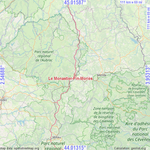
Le Monastier-Pin-Moriès GPS coordinates[2]
44° 31' 0.012" North, 3° 15' 0" East
| Map corner | latitude | longitude |
|---|---|---|
| Upper-left | 45.01587°, | 2.54688° |
| Center: | 44.51667°, | 3.25° |
| Lower-right: | 44.01315°, | 3.95313° |
| Map W x H: | 111.5×111.5 km | = 69.3×69.3mi |
| max Lat: | 51.07786° ⇑83.4% North |
| Le Monastier-Pin-Moriès: | 44.51667° |
| min Lat: | ⇓16.6% South 41.3874° |
| min Long | Le Monastier-Pi | max Long |
| -5.08615° | 3.25° | 9.52242° |
| W 61.3%⇐ | ⇒38.7% E |
Elevation
Elevation of Le Monastier-Pin-Moriès is 723 m = 2372 ft, and this is 529.3 m = 1737 ft above average elevation for this country.
| Max E: |
2333 m = 7654 ft | 3% |
| Le Monastier-Pin-Moriès | 723 m 2372 ft | |
| Avg. | 193.7 m = 635 ft | |
Min E: |
-1 m = -3 ft | 97% |
See also: France elevation on elevation.city.
Geographical zone
Le Monastier-Pin-Moriès is located in North temperate zone (between Tropic of Cancer and the Arctic Circle). Distance of this Northern Tropic circle is 2343.9 km =1456.4 mi to South.| Distance of | km | miles | from Le Monastier-Pin-Moriès |
|---|---|---|---|
| North Pole | 5057.3 | 3142.5 | to North |
| Arctic Circle | 2451.4 | 1523.2 | to North |
| Tropic Cancer | 2343.9 | 1456.4 | to South |
| Equator | 4949.8 | 3075.7 | to South |


Nearby cities:
15 places around Le Monastier-Pin-Moriès: (largest is in red/bold)
• Balsièges
16.9 km =10.5 mi,  103°
103°
• Banassac
9.8 km =6.1 mi,  204°
204°
• Barjac
12.9 km =8 mi, 96°
• Chanac
9.3 km =5.8 mi,  127°
127°
• Chastel-Nouvel
20.4 km =12.7 mi,  76°
76°
• Chirac
1.5 km =0.9 mi,  62°
62°
• La Canourgue
9.9 km =6.2 mi, 195°
• Marvejols
5.3 km =3.3 mi,  38°
38°
• Mende
20.1 km =12.5 mi,  89°
89°
• Montrodat
7.3 km =4.5 mi, 59°
• Nasbinals
22.8 km =14.2 mi,  315°
315°
• Rieutort-de-Randon
22.6 km =14 mi,  54°
54°
• Saint-Geniez-d’Olt
22.7 km =14.1 mi,  255°
255°
• Saint-Germain-du-Teil
7.5 km =4.7 mi,  235°
235°
• Sainte-Enimie
21.3 km =13.2 mi,  141°
141°
Sources, notices
• [Note1] Compared only with cities in France existing in our database
• [Src1] Map data: © OpenStreetMap contributors (CC-BY-SA)
• [Src2] Other city data from geonames.org with taken over terms of usage.
• [Src3] Geographical zone / Annual Mean Temperature by Robert A. Rohde @ Wikipedia
