Cuges-les-Pins geodata
Cuges-les-Pins (Provence-Alpes-Côte d'Azur) is a populated place; located in France in Europe/Paris (GMT+2) time zone. With population of 3,919 people, there are 2510 cities with bigger population in this country. Compared to other cities in France, 96.2% of cities are located further ↑North; 84.4% of cities are located further ←West and 65.6% of cities have lower elevation than Cuges-les-Pins. Note1
Administrative division(s):
- Level 1: Provence-Alpes-Côte d'Azur
- Level 2: Département des Bouches-du-Rhône
- Level 3: Arrondissement de Marseille
- Level 4: Cuges-les-Pins


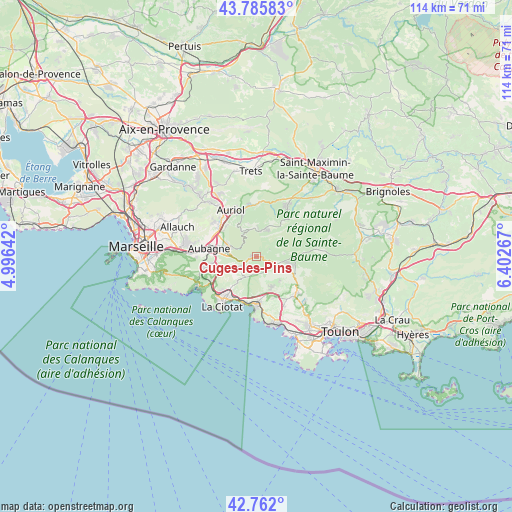
Cuges-les-Pins GPS coordinates[2]
43° 16' 33.852" North, 5° 41' 58.38" East
| Map corner | latitude | longitude |
|---|---|---|
| Upper-left | 43.78583°, | 4.99642° |
| Center: | 43.27607°, | 5.69955° |
| Lower-right: | 42.762°, | 6.40267° |
| Map W x H: | 113.8×113.8 km | = 70.7×70.7mi |
| max Lat: | 51.07786° ⇑96.2% North |
| Cuges-les-Pins: | 43.27607° |
| min Lat: | ⇓3.8% South 41.3874° |
| min Long | Cuges-les-Pins | max Long |
| -5.08615° | 5.69955° | 9.52242° |
| W 84.4%⇐ | ⇒15.6% E |
Elevation
Elevation of Cuges-les-Pins is 197 m = 646 ft, and this is 3.3 m = 11 ft above average elevation for this country.
| Max E: |
2333 m = 7654 ft | 34.4% |
| Cuges-les-Pins | 197 m 646 ft | |
| Avg. | 193.7 m = 635 ft | |
Min E: |
-1 m = -3 ft | 65.6% |
See also: France elevation on elevation.city.
Geographical zone
Cuges-les-Pins is located in North temperate zone (between Tropic of Cancer and the Arctic Circle). Distance of this Northern Tropic circle is 2205.9 km =1370.7 mi to South.| Distance of | km | miles | from Cuges-les-Pins |
|---|---|---|---|
| North Pole | 5195.2 | 3228.1 | to North |
| Arctic Circle | 2589.3 | 1608.9 | to North |
| Tropic Cancer | 2205.9 | 1370.7 | to South |
| Equator | 4811.8 | 2989.9 | to South |


Nearby cities:
15 places around Cuges-les-Pins: (largest is in red/bold)
• Aubagne
10.6 km =6.6 mi,  280°
280°
• Auriol
11.9 km =7.4 mi,  333°
333°
• Carnoux-en-Provence
11.2 km =7 mi,  258°
258°
• Ceyreste
9 km =5.6 mi,  219°
219°
• Gémenos
6.2 km =3.9 mi,  292°
292°
• La Destrousse
13.4 km =8.3 mi, 325°
• Le Beausset
12 km =7.5 mi,  136°
136°
• Le Castellet
10.3 km =6.4 mi, 142°
• Nans-les-Pins
12.4 km =7.7 mi,  32°
32°
• Plan-d'Aups-Sainte-Baume
6.5 km =4 mi,  12°
12°
• Roquefort-la-Bédoule
9.4 km =5.8 mi,  251°
251°
• Roquevaire
11.3 km =7 mi,  316°
316°
• Saint-Cyr-sur-Mer
10.6 km =6.6 mi,  179°
179°
• Saint-Zacharie
12.2 km =7.6 mi,  3°
3°
• Signes
13.3 km =8.3 mi,  82°
82°
Sources, notices
• [Note1] Compared only with cities in France existing in our database
• [Src1] Map data: © OpenStreetMap contributors (CC-BY-SA)
• [Src2] Other city data from geonames.org with taken over terms of usage.
• [Src3] Geographical zone / Annual Mean Temperature by Robert A. Rohde @ Wikipedia
