Aignan geodata
Aignan (Occitanie) is a populated place; located in France in Europe/Paris (GMT+2) time zone. With population of 949 people, there are 9213 cities with bigger population in this country. Compared to other cities in France, 90.5% of cities are located further ↑North; 77.3% of cities are located further →East and 59.8% of cities have lower elevation than Aignan. Note1
Administrative division(s):
- Level 1: Occitanie
- Level 2: Gers
- Level 3: Arrondissement de Mirande
- Level 4: Aignan


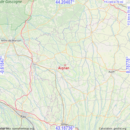
Aignan GPS coordinates[2]
43° 41' 52.332" North, 0° 5' 4.74" East
| Map corner | latitude | longitude |
|---|---|---|
| Upper-left | 44.20407°, | -0.61847° |
| Center: | 43.69787°, | 0.08465° |
| Lower-right: | 43.18736°, | 0.78778° |
| Map W x H: | 113×113 km | = 70.2×70.2mi |
| max Lat: | 51.07786° ⇑90.5% North |
| Aignan: | 43.69787° |
| min Lat: | ⇓9.5% South 41.3874° |
| min Long | Aignan | max Long |
| -5.08615° | 0.08465° | 9.52242° |
| W 22.7%⇐ | ⇒77.3% E |
Elevation
Elevation of Aignan is 169 m = 554 ft, and this is 24.7 m = 81 ft below average elevation for this country.
| Max E: |
2333 m = 7654 ft | 40.2% |
| Avg. | 193.7 m = 635 ft | |
| Aignan | 169 m = 554 ft | |
Min E: |
-1 m = -3 ft | 59.8% |
See also: France elevation on elevation.city.
Geographical zone
Aignan is located in North temperate zone (between Tropic of Cancer and the Arctic Circle). Distance of this Northern Tropic circle is 2252.8 km =1399.8 mi to South.| Distance of | km | miles | from Aignan |
|---|---|---|---|
| North Pole | 5148.3 | 3199 | to North |
| Arctic Circle | 2542.4 | 1579.8 | to North |
| Tropic Cancer | 2252.8 | 1399.8 | to South |
| Equator | 4858.7 | 3019.1 | to South |


Nearby cities:
15 places around Aignan: (largest is in red/bold)
• Beaumarchés
12.7 km =7.9 mi,  180°
180°
• Castelnau-Rivière-Basse
15.8 km =9.8 mi,  215°
215°
• Eauze
18.1 km =11.2 mi,  4°
4°
• Gondrin
24.1 km =15 mi,  30°
30°
• Lannepax
16.2 km =10.1 mi,  45°
45°
• Le Houga
22.8 km =14.2 mi,  292°
292°
• Madiran
19.7 km =12.2 mi,  213°
213°
• Manciet
11.8 km =7.3 mi,  343°
343°
• Marciac
20.4 km =12.7 mi,  162°
162°
• Montesquiou
23.8 km =14.8 mi,  123°
123°
• Nogaro
11.6 km =7.2 mi,  305°
305°
• Plaisance
10.8 km =6.7 mi,  196°
196°
• Riscle
14.5 km =9 mi,  251°
251°
• Vic-Fezensac
20.2 km =12.6 mi,  65°
65°
• Viella
21.1 km =13.1 mi,  238°
238°
Sources, notices
• [Note1] Compared only with cities in France existing in our database
• [Src1] Map data: © OpenStreetMap contributors (CC-BY-SA)
• [Src2] Other city data from geonames.org with taken over terms of usage.
• [Src3] Geographical zone / Annual Mean Temperature by Robert A. Rohde @ Wikipedia
