Canet geodata
Canet (Occitanie) is a populated place; located in France in Europe/Paris (GMT+2) time zone. With population of 1,801 people, there are 5275 cities with bigger population in this country. Compared to other cities in France, 96.8% of cities are located further ↑North; 55.7% of cities are located further ←West and 91.2% of cities have higher elevation than Canet. Note1
Administrative division(s):
- Level 1: Occitanie
- Level 2: Département de l'Aude
- Level 3: Arrondissement de Narbonne
- Level 4: Canet


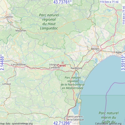
Canet GPS coordinates[2]
43° 13' 38.784" North, 2° 50' 52.8" East
| Map corner | latitude | longitude |
|---|---|---|
| Upper-left | 43.73761°, | 2.14488° |
| Center: | 43.22744°, | 2.848° |
| Lower-right: | 42.71296°, | 3.55113° |
| Map W x H: | 113.9×113.9 km | = 70.8×70.8mi |
| max Lat: | 51.07786° ⇑96.8% North |
| Canet: | 43.22744° |
| min Lat: | ⇓3.2% South 41.3874° |
| min Long | Canet | max Long |
| -5.08615° | 2.848° | 9.52242° |
| W 55.7%⇐ | ⇒44.3% E |
Elevation
Elevation of Canet is 27 m = 89 ft, and this is 166.7 m = 547 ft below average elevation for this country.
| Max E: |
2333 m = 7654 ft | 91.2% |
| Avg. | 193.7 m = 635 ft | |
| Canet | 27 m = 89 ft | |
Min E: |
-1 m = -3 ft | 8.8% |
See also: France elevation on elevation.city.
Geographical zone
Canet is located in North temperate zone (between Tropic of Cancer and the Arctic Circle). Distance of this Northern Tropic circle is 2200.5 km =1367.3 mi to South.| Distance of | km | miles | from Canet |
|---|---|---|---|
| North Pole | 5200.6 | 3231.5 | to North |
| Arctic Circle | 2594.7 | 1612.3 | to North |
| Tropic Cancer | 2200.5 | 1367.3 | to South |
| Equator | 4806.4 | 2986.6 | to South |


Nearby cities:
15 places around Canet: (largest is in red/bold)
• Bizanet
7.3 km =4.5 mi,  165°
165°
• Boutenac
10 km =6.2 mi,  207°
207°
• Ginestas
4.7 km =2.9 mi,  22°
22°
• Luc-sur-Orbieu
7.6 km =4.7 mi,  222°
222°
• Lézignan-Corbières
7.8 km =4.8 mi,  244°
244°
• Marcorignan
6.1 km =3.8 mi,  91°
91°
• Mirepeisset
7.5 km =4.7 mi,  33°
33°
• Montredon-des-Corbières
8.5 km =5.3 mi,  125°
125°
• Moussan
8.3 km =5.2 mi, 87°
• Névian
4.8 km =3 mi,  110°
110°
• Ornaisons
5.3 km =3.3 mi,  189°
189°
• Saint-Marcel-sur-Aude
7.4 km =4.6 mi,  70°
70°
• Saint-Nazaire-d’Aude
4.2 km =2.6 mi,  62°
62°
• Sainte-Valière
5.1 km =3.2 mi,  354°
354°
• Ventenac-en-Minervois
2.9 km =1.8 mi, 31°
Sources, notices
• [Note1] Compared only with cities in France existing in our database
• [Src1] Map data: © OpenStreetMap contributors (CC-BY-SA)
• [Src2] Other city data from geonames.org with taken over terms of usage.
• [Src3] Geographical zone / Annual Mean Temperature by Robert A. Rohde @ Wikipedia
