Dieupentale geodata
Dieupentale (Occitanie) is a populated place; located in France in Europe/Paris (GMT+2) time zone. With population of 781 people, there are 10811 cities with bigger population in this country. Compared to other cities in France, 88.5% of cities are located further ↑North; 65.9% of cities are located further →East and 57.6% of cities have higher elevation than Dieupentale. Note1
Administrative division(s):
- Level 1: Occitanie
- Level 2: Département du Tarn-et-Garonne
- Level 3: Arrondissement de Montauban
- Level 4: Dieupentale


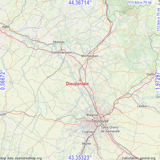
Dieupentale GPS coordinates[2]
43° 51' 44.424" North, 1° 16' 11.46" East
| Map corner | latitude | longitude |
|---|---|---|
| Upper-left | 44.36714°, | 0.56672° |
| Center: | 43.86234°, | 1.26985° |
| Lower-right: | 43.35323°, | 1.97297° |
| Map W x H: | 112.7×112.7 km | = 70×70mi |
| max Lat: | 51.07786° ⇑88.5% North |
| Dieupentale: | 43.86234° |
| min Lat: | ⇓11.5% South 41.3874° |
| min Long | Dieupentale | max Long |
| -5.08615° | 1.26985° | 9.52242° |
| W 34.1%⇐ | ⇒65.9% E |
Elevation
Elevation of Dieupentale is 109 m = 358 ft, and this is 84.7 m = 278 ft below average elevation for this country.
| Max E: |
2333 m = 7654 ft | 57.6% |
| Avg. | 193.7 m = 635 ft | |
| Dieupentale | 109 m = 358 ft | |
Min E: |
-1 m = -3 ft | 42.4% |
See also: France elevation on elevation.city.
Geographical zone
Dieupentale is located in North temperate zone (between Tropic of Cancer and the Arctic Circle). Distance of this Northern Tropic circle is 2271.1 km =1411.2 mi to South.| Distance of | km | miles | from Dieupentale |
|---|---|---|---|
| North Pole | 5130 | 3187.6 | to North |
| Arctic Circle | 2524.1 | 1568.4 | to North |
| Tropic Cancer | 2271.1 | 1411.2 | to South |
| Equator | 4877 | 3030.4 | to South |


Nearby cities:
15 places around Dieupentale: (largest is in red/bold)
• Aucamville
8 km =5 mi,  213°
213°
• Bessens
2.2 km =1.4 mi,  324°
324°
• Campsas
5.9 km =3.7 mi,  50°
50°
• Canals
2.1 km =1.3 mi,  123°
123°
• Finhan
6.9 km =4.3 mi,  325°
325°
• Fronton
9.9 km =6.2 mi,  104°
104°
• Grenade
10.7 km =6.6 mi,  174°
174°
• Grisolles
4.3 km =2.7 mi,  149°
149°
• Labastide-Saint-Pierre
9.9 km =6.2 mi, 51°
• Mas-Grenier
6.8 km =4.2 mi,  298°
298°
• Montbartier
5.7 km =3.5 mi,  3°
3°
• Ondes
9.4 km =5.8 mi,  160°
160°
• Pompignan
6 km =3.7 mi, 145°
• Savenès
6.6 km =4.1 mi,  239°
239°
• Verdun-sur-Garonne
3 km =1.9 mi,  252°
252°
Sources, notices
• [Note1] Compared only with cities in France existing in our database
• [Src1] Map data: © OpenStreetMap contributors (CC-BY-SA)
• [Src2] Other city data from geonames.org with taken over terms of usage.
• [Src3] Geographical zone / Annual Mean Temperature by Robert A. Rohde @ Wikipedia
