Châteauneuf-du-Pape geodata
Châteauneuf-du-Pape (Provence-Alpes-Côte d'Azur) is a populated place; located in France in Europe/Paris (GMT+2) time zone. With population of 2,212 people, there are 4343 cities with bigger population in this country. Compared to other cities in France, 86.6% of cities are located further ↑North; 75.5% of cities are located further ←West and 71.9% of cities have higher elevation than Châteauneuf-du-Pape. Note1
Administrative division(s):
- Level 1: Provence-Alpes-Côte d'Azur
- Level 2: Département du Vaucluse
- Level 3: Arrondissement de Carpentras
- Level 4: Châteauneuf-du-Pape


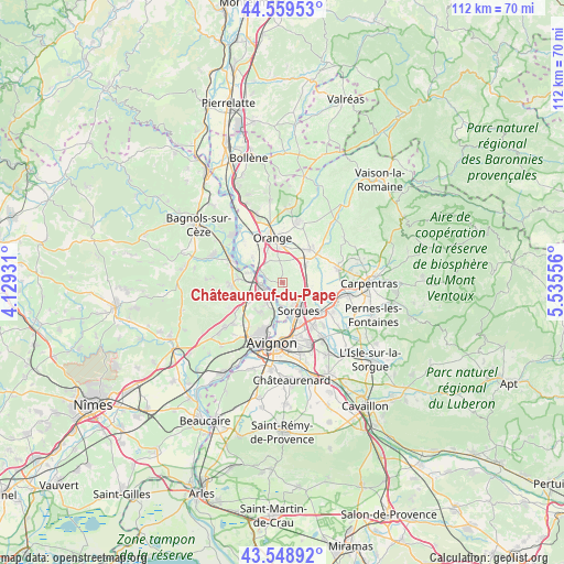
Châteauneuf-du-Pape GPS coordinates[2]
44° 3' 22.968" North, 4° 49' 56.784" East
| Map corner | latitude | longitude |
|---|---|---|
| Upper-left | 44.55953°, | 4.12931° |
| Center: | 44.05638°, | 4.83244° |
| Lower-right: | 43.54892°, | 5.53556° |
| Map W x H: | 112.4×112.4 km | = 69.8×69.8mi |
| max Lat: | 51.07786° ⇑86.6% North |
| Châteauneuf-du-Pape: | 44.05638° |
| min Lat: | ⇓13.4% South 41.3874° |
| min Long | Châteauneuf-du | max Long |
| -5.08615° | 4.83244° | 9.52242° |
| W 75.5%⇐ | ⇒24.5% E |
Elevation
Elevation of Châteauneuf-du-Pape is 74 m = 243 ft, and this is 119.7 m = 393 ft below average elevation for this country.
| Max E: |
2333 m = 7654 ft | 71.9% |
| Avg. | 193.7 m = 635 ft | |
| Châteauneuf-du-Pape | 74 m = 243 ft | |
Min E: |
-1 m = -3 ft | 28.1% |
See also: France elevation on elevation.city.
Geographical zone
Châteauneuf-du-Pape is located in North temperate zone (between Tropic of Cancer and the Arctic Circle). Distance of this Northern Tropic circle is 2292.7 km =1424.6 mi to South.| Distance of | km | miles | from Châteauneuf-du-Pape |
|---|---|---|---|
| North Pole | 5108.5 | 3174.3 | to North |
| Arctic Circle | 2502.6 | 1555 | to North |
| Tropic Cancer | 2292.7 | 1424.6 | to South |
| Equator | 4898.6 | 3043.8 | to South |


Nearby cities:
15 places around Châteauneuf-du-Pape: (largest is in red/bold)
• Bédarrides
5.6 km =3.5 mi,  108°
108°
• Caderousse
8 km =5 mi,  310°
310°
• Courthézon
5.4 km =3.4 mi,  49°
49°
• Entraigues-sur-la-Sorgue
9.6 km =6 mi,  128°
128°
• Jonquières
8.5 km =5.3 mi,  39°
39°
• Montfaucon
6.4 km =4 mi,  286°
286°
• Orange
9.3 km =5.8 mi,  348°
348°
• Pujaut
7.4 km =4.6 mi,  217°
217°
• Roquemaure
4.5 km =2.8 mi,  260°
260°
• Saint-Geniès-de-Comolas
8.9 km =5.5 mi,  277°
277°
• Saint-Laurent-des-Arbres
10.6 km =6.6 mi,  269°
269°
• Sauveterre
4.9 km =3 mi, 219°
• Sorgues
6.1 km =3.8 mi,  147°
147°
• Vedène
10.5 km =6.5 mi, 146°
• Villeneuve-lès-Avignon
10.2 km =6.3 mi,  196°
196°
Sources, notices
• [Note1] Compared only with cities in France existing in our database
• [Src1] Map data: © OpenStreetMap contributors (CC-BY-SA)
• [Src2] Other city data from geonames.org with taken over terms of usage.
• [Src3] Geographical zone / Annual Mean Temperature by Robert A. Rohde @ Wikipedia
