Busque geodata
Busque (Occitanie) is a populated place; located in France in Europe/Paris (GMT+2) time zone. With population of 617 people, there are 13032 cities with bigger population in this country. Compared to other cities in France, 89.3% of cities are located further ↑North; 57.6% of cities are located further →East and 58.4% of cities have lower elevation than Busque. Note1
Administrative division(s):
- Level 1: Occitanie
- Level 2: Tarn
- Level 3: Arrondissement de Castres
- Level 4: Busque


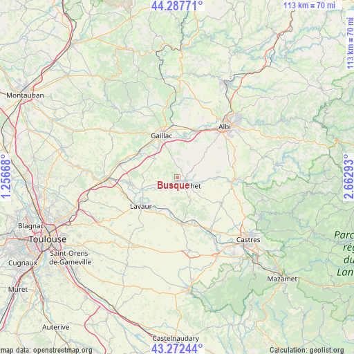
Busque GPS coordinates[2]
43° 46' 56.028" North, 1° 57' 35.28" East
| Map corner | latitude | longitude |
|---|---|---|
| Upper-left | 44.28771°, | 1.25668° |
| Center: | 43.78223°, | 1.9598° |
| Lower-right: | 43.27244°, | 2.66293° |
| Map W x H: | 112.9×112.9 km | = 70.2×70.2mi |
| max Lat: | 51.07786° ⇑89.3% North |
| Busque: | 43.78223° |
| min Lat: | ⇓10.7% South 41.3874° |
| min Long | Busque | max Long |
| -5.08615° | 1.9598° | 9.52242° |
| W 42.4%⇐ | ⇒57.6% E |
Elevation
Elevation of Busque is 163 m = 535 ft, and this is 30.7 m = 101 ft below average elevation for this country.
| Max E: |
2333 m = 7654 ft | 41.6% |
| Avg. | 193.7 m = 635 ft | |
| Busque | 163 m = 535 ft | |
Min E: |
-1 m = -3 ft | 58.4% |
See also: France elevation on elevation.city.
Geographical zone
Busque is located in North temperate zone (between Tropic of Cancer and the Arctic Circle). Distance of this Northern Tropic circle is 2262.2 km =1405.7 mi to South.| Distance of | km | miles | from Busque |
|---|---|---|---|
| North Pole | 5138.9 | 3193.2 | to North |
| Arctic Circle | 2533 | 1573.9 | to North |
| Tropic Cancer | 2262.2 | 1405.7 | to South |
| Equator | 4868.1 | 3024.9 | to South |


Nearby cities:
15 places around Busque: (largest is in red/bold)
• Ambres
13.1 km =8.1 mi,  244°
244°
• Brens
12.4 km =7.7 mi,  340°
340°
• Briatexte
5.3 km =3.3 mi,  230°
230°
• Cadalen
7.7 km =4.8 mi,  12°
12°
• Fiac
9.9 km =6.2 mi,  205°
205°
• Florentin
13.2 km =8.2 mi,  26°
26°
• Graulhet
2.9 km =1.8 mi,  125°
125°
• Labastide-Saint-Georges
13 km =8.1 mi,  224°
224°
• Labessière-Candeil
4.3 km =2.7 mi,  58°
58°
• Lagrave
13.1 km =8.1 mi, 11°
• Montans
11.1 km =6.9 mi,  327°
327°
• Parisot
10.7 km =6.6 mi,  280°
280°
• Rouffiac
14.2 km =8.8 mi,  37°
37°
• Saint-Gauzens
6.2 km =3.9 mi, 231°
• Técou
6.9 km =4.3 mi,  353°
353°
Sources, notices
• [Note1] Compared only with cities in France existing in our database
• [Src1] Map data: © OpenStreetMap contributors (CC-BY-SA)
• [Src2] Other city data from geonames.org with taken over terms of usage.
• [Src3] Geographical zone / Annual Mean Temperature by Robert A. Rohde @ Wikipedia
