Bruc-sur-Aff geodata
Bruc-sur-Aff (Brittany) is a populated place; located in France in Europe/Paris (GMT+2) time zone. With population of 856 people, there are 10023 cities with bigger population in this country. Compared to other cities in France, 56% of cities are located further ↓South; 94.9% of cities are located further →East and 84.9% of cities have higher elevation than Bruc-sur-Aff. Note1
Administrative division(s):
- Level 1: Brittany
- Level 2: Département d'Ille-et-Vilaine
- Level 3: Arrondissement de Redon
- Level 4: Bruc-sur-Aff


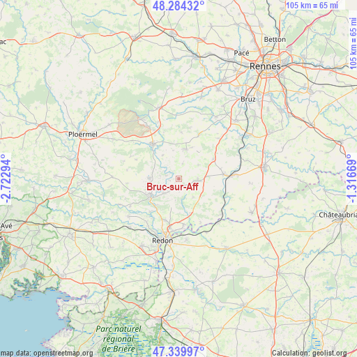
Bruc-sur-Aff GPS coordinates[2]
47° 48' 51.444" North, 2° 1' 11.316" West
| Map corner | latitude | longitude |
|---|---|---|
| Upper-left | 48.28432°, | -2.72294° |
| Center: | 47.81429°, | -2.01981° |
| Lower-right: | 47.33997°, | -1.31669° |
| Map W x H: | 105×105 km | = 65.2×65.2mi |
| max Lat: | 51.07786° ⇑44% North |
| Bruc-sur-Aff: | 47.81429° |
| min Lat: | ⇓56% South 41.3874° |
| min Long | Bruc-sur-Aff | max Long |
| -5.08615° | -2.01981° | 9.52242° |
| W 5.1%⇐ | ⇒94.9% E |
Elevation
Elevation of Bruc-sur-Aff is 42 m = 138 ft, and this is 151.7 m = 498 ft below average elevation for this country.
| Max E: |
2333 m = 7654 ft | 84.9% |
| Avg. | 193.7 m = 635 ft | |
| Bruc-sur-Aff | 42 m = 138 ft | |
Min E: |
-1 m = -3 ft | 15.1% |
See also: France elevation on elevation.city.
Geographical zone
Bruc-sur-Aff is located in North temperate zone (between Tropic of Cancer and the Arctic Circle). Distance of this North polar circle is 2084.7 km =1295.4 mi to North.| Distance of | km | miles | from Bruc-sur-Aff |
|---|---|---|---|
| North Pole | 4690.6 | 2914.6 | to North |
| Arctic Circle | 2084.7 | 1295.4 | to North |
| Tropic Cancer | 2710.5 | 1684.2 | to South |
| Equator | 5316.5 | 3303.5 | to South |


Nearby cities:
15 places around Bruc-sur-Aff: (largest is in red/bold)
• Carentoir
8.5 km =5.3 mi,  271°
271°
• Comblessac
8.4 km =5.2 mi,  325°
325°
• Cournon
10.1 km =6.3 mi,  220°
220°
• Guer
12.8 km =8 mi,  322°
322°
• La Chapelle-Gaceline
7.3 km =4.5 mi,  242°
242°
• La Gacilly
10 km =6.2 mi, 237°
• Lieuron
7.1 km =4.4 mi,  54°
54°
• Lohéac
11.7 km =7.3 mi,  60°
60°
• Maure-de-Bretagne
8.9 km =5.5 mi,  13°
13°
• Mernel
9.9 km =6.2 mi,  22°
22°
• Pipriac
5.5 km =3.4 mi,  95°
95°
• Quelneuc
3.6 km =2.2 mi,  287°
287°
• Renac
11 km =6.8 mi,  162°
162°
• Saint-Just
7 km =4.3 mi,  140°
140°
• Sixt-sur-Aff
6.1 km =3.8 mi,  226°
226°
Sources, notices
• [Note1] Compared only with cities in France existing in our database
• [Src1] Map data: © OpenStreetMap contributors (CC-BY-SA)
• [Src2] Other city data from geonames.org with taken over terms of usage.
• [Src3] Geographical zone / Annual Mean Temperature by Robert A. Rohde @ Wikipedia
