Cesson-Sévigné geodata
Cesson-Sévigné (Brittany) is a populated place; located in France in Europe/Paris (GMT+2) time zone. With population of 16,222 people, there are 584 cities with bigger population in this country. Compared to other cities in France, 61.6% of cities are located further ↓South; 93% of cities are located further →East and 87.1% of cities have higher elevation than Cesson-Sévigné. Note1
Administrative division(s):
- Level 1: Brittany
- Level 2: Département d'Ille-et-Vilaine
- Level 3: Arrondissement de Rennes
- Level 4: Cesson-Sévigné


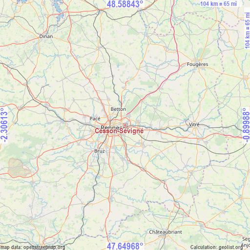
Cesson-Sévigné GPS coordinates[2]
48° 7' 16.32" North, 1° 36' 10.8" West
| Map corner | latitude | longitude |
|---|---|---|
| Upper-left | 48.58843°, | -2.30613° |
| Center: | 48.1212°, | -1.603° |
| Lower-right: | 47.64968°, | -0.89988° |
| Map W x H: | 104.4×104.4 km | = 64.9×64.9mi |
| max Lat: | 51.07786° ⇑38.4% North |
| Cesson-Sévigné: | 48.1212° |
| min Lat: | ⇓61.6% South 41.3874° |
| min Long | Cesson-Sévign� | max Long |
| -5.08615° | -1.603° | 9.52242° |
| W 7%⇐ | ⇒93% E |
Elevation
Elevation of Cesson-Sévigné is 37 m = 121 ft, and this is 156.7 m = 514 ft below average elevation for this country.
| Max E: |
2333 m = 7654 ft | 87.1% |
| Avg. | 193.7 m = 635 ft | |
| Cesson-Sévigné | 37 m = 121 ft | |
Min E: |
-1 m = -3 ft | 12.9% |
See also: France elevation on elevation.city.
Geographical zone
Cesson-Sévigné is located in North temperate zone (between Tropic of Cancer and the Arctic Circle). Distance of this North polar circle is 2050.6 km =1274.2 mi to North.| Distance of | km | miles | from Cesson-Sévigné |
|---|---|---|---|
| North Pole | 4656.5 | 2893.4 | to North |
| Arctic Circle | 2050.6 | 1274.2 | to North |
| Tropic Cancer | 2744.7 | 1705.5 | to South |
| Equator | 5350.6 | 3324.7 | to South |


Nearby cities:
15 places around Cesson-Sévigné: (largest is in red/bold)
• Acigné
5.1 km =3.2 mi,  74°
74°
• Betton
7.1 km =4.4 mi,  338°
338°
• Brécé
9.2 km =5.7 mi,  98°
98°
• Chantepie
3.7 km =2.3 mi,  194°
194°
• Chevaigné
10.2 km =6.3 mi,  348°
348°
• Fouillard
4.5 km =2.8 mi,  23°
23°
• Montgermont
9.1 km =5.7 mi,  294°
294°
• Nouvoitou
9.8 km =6.1 mi,  155°
155°
• Noyal-sur-Vilaine
6 km =3.7 mi, 99°
• Rennes
5.4 km =3.4 mi,  259°
259°
• Saint-Grégoire
7.1 km =4.4 mi,  297°
297°
• Saint-Jacques-de-la-Lande
10.7 km =6.6 mi,  234°
234°
• Saint-Sulpice-la-Forêt
10.8 km =6.7 mi,  9°
9°
• Servon-sur-Vilaine
10.6 km =6.6 mi,  90°
90°
• Vern-sur-Seiche
8.5 km =5.3 mi,  178°
178°
Sources, notices
• [Note1] Compared only with cities in France existing in our database
• [Src1] Map data: © OpenStreetMap contributors (CC-BY-SA)
• [Src2] Other city data from geonames.org with taken over terms of usage.
• [Src3] Geographical zone / Annual Mean Temperature by Robert A. Rohde @ Wikipedia
