Fouillard geodata
Fouillard (Brittany) is a populated place; located in France in Europe/Paris (GMT+2) time zone. With population of 6,737 people, there are 1476 cities with bigger population in this country. Compared to other cities in France, 62.1% of cities are located further ↓South; 92.8% of cities are located further →East and 69.2% of cities have higher elevation than Fouillard. Note1
Administrative division(s):
- Level 1: Brittany
- Level 2: Département d'Ille-et-Vilaine
- Level 3: Arrondissement de Rennes
- Level 4: Thorigné-Fouillard


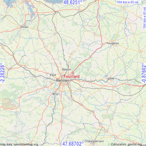
Fouillard GPS coordinates[2]
48° 9' 29.52" North, 1° 34' 44.94" West
| Map corner | latitude | longitude |
|---|---|---|
| Upper-left | 48.6251°, | -2.28228° |
| Center: | 48.1582°, | -1.57915° |
| Lower-right: | 47.68702°, | -0.87602° |
| Map W x H: | 104.3×104.3 km | = 64.8×64.8mi |
| max Lat: | 51.07786° ⇑37.9% North |
| Fouillard: | 48.1582° |
| min Lat: | ⇓62.1% South 41.3874° |
| min Long | Fouillard | max Long |
| -5.08615° | -1.57915° | 9.52242° |
| W 7.2%⇐ | ⇒92.8% E |
Elevation
Elevation of Fouillard is 80 m = 262 ft, and this is 113.7 m = 373 ft below average elevation for this country.
| Max E: |
2333 m = 7654 ft | 69.2% |
| Avg. | 193.7 m = 635 ft | |
| Fouillard | 80 m = 262 ft | |
Min E: |
-1 m = -3 ft | 30.8% |
See also: France elevation on elevation.city.
Geographical zone
Fouillard is located in North temperate zone (between Tropic of Cancer and the Arctic Circle). Distance of this North polar circle is 2046.5 km =1271.6 mi to North.| Distance of | km | miles | from Fouillard |
|---|---|---|---|
| North Pole | 4652.4 | 2890.9 | to North |
| Arctic Circle | 2046.5 | 1271.6 | to North |
| Tropic Cancer | 2748.8 | 1708 | to South |
| Equator | 5354.7 | 3327.3 | to South |


Nearby cities:
15 places around Fouillard: (largest is in red/bold)
• Acigné
4.2 km =2.6 mi,  131°
131°
• Betton
5 km =3.1 mi,  299°
299°
• Brécé
9.2 km =5.7 mi, 127°
• Cesson-Sévigné
4.5 km =2.8 mi,  203°
203°
• Chantepie
8.2 km =5.1 mi, 199°
• Chasné-sur-Illet
9.5 km =5.9 mi,  8°
8°
• Chevaigné
7 km =4.3 mi,  327°
327°
• Liffré
8.1 km =5 mi,  40°
40°
• Montgermont
10.1 km =6.3 mi,  268°
268°
• Mouazé
8.5 km =5.3 mi,  344°
344°
• Noyal-sur-Vilaine
6.6 km =4.1 mi,  141°
141°
• Rennes
8.7 km =5.4 mi,  233°
233°
• Saint-Grégoire
8 km =5 mi,  264°
264°
• Saint-Sulpice-la-Forêt
6.5 km =4 mi,  359°
359°
• Servon-sur-Vilaine
9.8 km =6.1 mi,  114°
114°
Sources, notices
• [Note1] Compared only with cities in France existing in our database
• [Src1] Map data: © OpenStreetMap contributors (CC-BY-SA)
• [Src2] Other city data from geonames.org with taken over terms of usage.
• [Src3] Geographical zone / Annual Mean Temperature by Robert A. Rohde @ Wikipedia
