Bonnat geodata
Bonnat (Nouvelle-Aquitaine) is a populated place; located in France in Europe/Paris (GMT+2) time zone. With population of 1,293 people, there are 7069 cities with bigger population in this country. Compared to other cities in France, 61.9% of cities are located further ↑North; 58.2% of cities are located further →East and 85% of cities have lower elevation than Bonnat. Note1
Administrative division(s):
- Level 1: Nouvelle-Aquitaine
- Level 2: Creuse
- Level 3: Arrondissement de Guéret
- Level 4: Bonnat


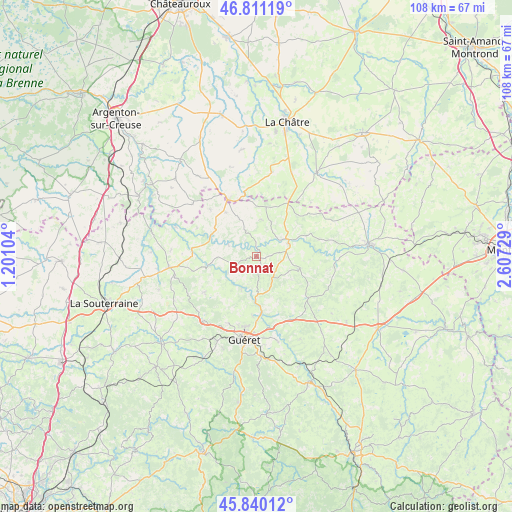
Bonnat GPS coordinates[2]
46° 19' 40.116" North, 1° 54' 15.012" East
| Map corner | latitude | longitude |
|---|---|---|
| Upper-left | 46.81119°, | 1.20104° |
| Center: | 46.32781°, | 1.90417° |
| Lower-right: | 45.84012°, | 2.60729° |
| Map W x H: | 108×108 km | = 67.1×67.1mi |
| max Lat: | 51.07786° ⇑61.9% North |
| Bonnat: | 46.32781° |
| min Lat: | ⇓38.1% South 41.3874° |
| min Long | Bonnat | max Long |
| -5.08615° | 1.90417° | 9.52242° |
| W 41.8%⇐ | ⇒58.2% E |
Elevation
Elevation of Bonnat is 346 m = 1135 ft, and this is 152.3 m = 500 ft above average elevation for this country.
| Max E: |
2333 m = 7654 ft | 15% |
| Bonnat | 346 m 1135 ft | |
| Avg. | 193.7 m = 635 ft | |
Min E: |
-1 m = -3 ft | 85% |
See also: France elevation on elevation.city.
Geographical zone
Bonnat is located in North temperate zone (between Tropic of Cancer and the Arctic Circle). Distance of this North polar circle is 2250 km =1398.1 mi to North.| Distance of | km | miles | from Bonnat |
|---|---|---|---|
| North Pole | 4855.9 | 3017.3 | to North |
| Arctic Circle | 2250 | 1398.1 | to North |
| Tropic Cancer | 2545.3 | 1581.6 | to South |
| Equator | 5151.2 | 3200.8 | to South |


Nearby cities:
15 places around Bonnat: (largest is in red/bold)
• Aigurande
13.1 km =8.1 mi,  334°
334°
• Ajain
15.2 km =9.4 mi,  151°
151°
• Anzême
7.5 km =4.7 mi,  204°
204°
• Bussière-Dunoise
13.4 km =8.3 mi,  234°
234°
• Châtelus-Malvaleix
9.5 km =5.9 mi,  105°
105°
• Chéniers
6.4 km =4 mi,  293°
293°
• Genouillac
7.3 km =4.5 mi,  68°
68°
• Glénic
11.7 km =7.3 mi,  173°
173°
• La Celle-Dunoise
10.4 km =6.5 mi,  258°
258°
• Lourdoueix-Saint-Pierre
11.1 km =6.9 mi, 325°
• Moutier-Malcard
8 km =5 mi,  22°
22°
• Méasnes
13.8 km =8.6 mi,  315°
315°
• Saint-Fiel
12.7 km =7.9 mi,  183°
183°
• Saint-Sulpice-le-Dunois
13.8 km =8.6 mi, 256°
• Saint-Sulpice-le-Guérétois
15.3 km =9.5 mi, 202°
Sources, notices
• [Note1] Compared only with cities in France existing in our database
• [Src1] Map data: © OpenStreetMap contributors (CC-BY-SA)
• [Src2] Other city data from geonames.org with taken over terms of usage.
• [Src3] Geographical zone / Annual Mean Temperature by Robert A. Rohde @ Wikipedia
