Boissy-Fresnoy geodata
Boissy-Fresnoy (Hauts-de-France) is a populated place; located in France in Europe/Paris (GMT+2) time zone. With population of 827 people, there are 10320 cities with bigger population in this country. Compared to other cities in France, 83.6% of cities are located further ↓South; 56% of cities are located further ←West and 50.5% of cities have higher elevation than Boissy-Fresnoy. Note1
Administrative division(s):
- Level 1: Hauts-de-France
- Level 2: Département de l'Oise
- Level 3: Arrondissement de Senlis
- Level 4: Boissy-Fresnoy


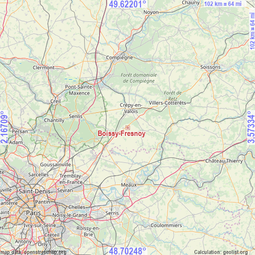
Boissy-Fresnoy GPS coordinates[2]
49° 9' 51.768" North, 2° 52' 12.792" East
| Map corner | latitude | longitude |
|---|---|---|
| Upper-left | 49.62201°, | 2.16709° |
| Center: | 49.16438°, | 2.87022° |
| Lower-right: | 48.70248°, | 3.57334° |
| Map W x H: | 102.2×102.2 km | = 63.5×63.5mi |
| max Lat: | 51.07786° ⇑16.4% North |
| Boissy-Fresnoy: | 49.16438° |
| min Lat: | ⇓83.6% South 41.3874° |
| min Long | Boissy-Fresnoy | max Long |
| -5.08615° | 2.87022° | 9.52242° |
| W 56%⇐ | ⇒44% E |
Elevation
Elevation of Boissy-Fresnoy is 130 m = 427 ft, and this is 63.7 m = 209 ft below average elevation for this country.
| Max E: |
2333 m = 7654 ft | 50.5% |
| Avg. | 193.7 m = 635 ft | |
| Boissy-Fresnoy | 130 m = 427 ft | |
Min E: |
-1 m = -3 ft | 49.5% |
See also: France elevation on elevation.city.
Geographical zone
Boissy-Fresnoy is located in North temperate zone (between Tropic of Cancer and the Arctic Circle). Distance of this North polar circle is 1934.6 km =1202.1 mi to North.| Distance of | km | miles | from Boissy-Fresnoy |
|---|---|---|---|
| North Pole | 4540.5 | 2821.3 | to North |
| Arctic Circle | 1934.6 | 1202.1 | to North |
| Tropic Cancer | 2860.6 | 1777.5 | to South |
| Equator | 5466.6 | 3396.8 | to South |


Nearby cities:
15 places around Boissy-Fresnoy: (largest is in red/bold)
• Acy-en-Multien
9.1 km =5.7 mi,  137°
137°
• Baron
10.2 km =6.3 mi,  275°
275°
• Betz
6.3 km =3.9 mi,  98°
98°
• Brégy
9.1 km =5.7 mi,  182°
182°
• Crépy-en-Valois
7.8 km =4.8 mi,  9°
9°
• Lagny-le-Sec
12.5 km =7.8 mi,  226°
226°
• Le Plessis-Belleville
11.3 km =7 mi, 227°
• Lévignen
5.2 km =3.2 mi,  40°
40°
• Nanteuil-le-Haudouin
5 km =3.1 mi,  238°
238°
• Oissery
11.1 km =6.9 mi,  199°
199°
• Péroy-les-Gombries
1.8 km =1.1 mi,  263°
263°
• Saint-Pathus
11.6 km =7.2 mi,  206°
206°
• Silly-le-Long
8.5 km =5.3 mi,  221°
221°
• Trumilly
10.1 km =6.3 mi,  330°
330°
• Vaumoise
11.3 km =7 mi,  45°
45°
Sources, notices
• [Note1] Compared only with cities in France existing in our database
• [Src1] Map data: © OpenStreetMap contributors (CC-BY-SA)
• [Src2] Other city data from geonames.org with taken over terms of usage.
• [Src3] Geographical zone / Annual Mean Temperature by Robert A. Rohde @ Wikipedia
